
In the world of commercial drone operations, there is a massive divide between "taking a picture" and "capturing data." For construction managers, property developers, and facility directors in Southwest Florida, that divide often translates to thousands of dollars in wasted resources or missed defects.
Precision isn't an accident. It is the result of high-spec hardware, rigorous flight standards, and professional data processing. If your drone data feels "off": or if your thermal maps are blurry and your orthomosaics look like a funhouse mirror: you are likely a victim of one of these ten common pitfalls.
At Cape UAV, we specialize in closing that gap using enterprise-grade equipment and FAA Part 107 expertise. Here is why your data might be failing you and how we ensure precision on every mission.
1. Using Consumer-Grade Hardware for Enterprise Tasks
The most common cause of poor data is the "off-the-shelf" hobbyist drone. Consumer drones are built for social media, not for high-resolution aerial mapping or thermal inspections. They lack the sensor size and stability required for professional deliverables.
The Pro Fix:
Professional pilots utilize enterprise platforms like the Autel Robotics EVO Lite 6T Enterprise (EVO Lite 640T). This aircraft features a 50MP visual camera and a dedicated 640×512 thermal sensor. This level of hardware provides the raw data density needed for high-resolution orthomosaics and 3D modeling.
Note: Autel Robotics is a trademark of its respective owner; Cape UAV is not affiliated with or endorsed by Autel Robotics.
2. Low-Resolution Thermal Sensors
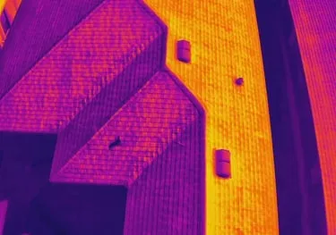
Thermal imaging is often misunderstood. A "thermal camera" on a cheap drone might only have a resolution of 160×120 or 320×240. When you are looking for a micro-leak in a commercial roof or a failing cell in a solar array, those low-res pixels turn into a blurry mess.
The Pro Fix:
We utilize sensors with a 640×512 resolution and a 12um pixel pitch. This technical specification allows for much higher thermal sensitivity and clearer imagery, even from a distance.
Why This Matters:
- Identification: Detects thermal anomalies before they become catastrophic failures.
- Clarity: Distinguishes between a reflection and an actual heat leak.
- Efficiency: Covers more ground without sacrificing the ability to spot small issues.
3. Motion Blur and Incorrect Shutter Speed
Precision mapping requires crisp images. If a drone is flying too fast or the shutter speed is too slow, the resulting images will have "motion blur." You might not notice it on a single photo, but when you try to stitch 500 photos into an orthomosaic map, the software will struggle to align the blurred features.
The Pro Fix:
Part 107 pilots calculate the maximum allowable flight speed based on the camera’s shutter speed and the Ground Sampling Distance (GSD). We prioritize faster shutter speeds and consistent flight paths to ensure every pixel is sharp.
4. Insufficient Image Overlap
For photogrammetry to work, each photo must overlap with its neighbor. If the overlap is too low (e.g., 50% or 60%), the software lacks enough matching points to build a reliable 3D model or map. This leads to "holes" in your data or warped geometry.
The Pro Fix:
We typically aim for at least 80% frontal overlap and 70% side overlap. This creates a dense web of data points, allowing for the creation of high-resolution 3D models for land development and site planning.

5. Ignoring Atmospheric and Environmental Conditions
Southwest Florida is famous for high humidity, heat haze, and sudden wind gusts. High humidity can scatter thermal radiation, leading to inaccurate temperature readings. High winds can cause the drone to tilt, changing the camera angle and distorting the mapping perspective.
The Pro Fix:
Professional pilots monitor more than just the rain. We track K-index (solar activity), humidity levels, and wind shear. For thermal inspections, we often fly during "thermal crossover" periods or specific times of day to ensure the best possible contrast for identifying anomalies.
6. Lack of Ground Control Points (GCPs)
Without a way to tie the drone's GPS data to the actual ground, a map can shift. While drone GPS is great for navigation, it isn't always enough to ensure that the digital map lines up perfectly with real-world coordinates over a large site.
The Pro Fix:
While we do not provide licensed land surveys, we use sophisticated workflows to ensure our high-resolution mapping is as reliable as possible for planning purposes. This involves using consistent markers and advanced processing to align the data with the site’s physical features.
7. Improper Camera Calibration
Every camera lens has slight distortions. If the processing software doesn't know the exact "internal parameters" of the lens (focal length, principal point, etc.), the resulting map will have errors.
The Pro Fix:
Pro pilots perform regular sensor calibrations and use high-end software that accounts for the specific lens profiles of enterprise equipment like the Autel Lite 6T.
8. Failure to Account for Nadir vs. Oblique Angles
If you are mapping a flat field, a "nadir" (straight down) camera angle is fine. However, if you are documenting a construction site with vertical structures or stockpiles, you need "oblique" (angled) shots to capture the sides of objects.
The Pro Fix:
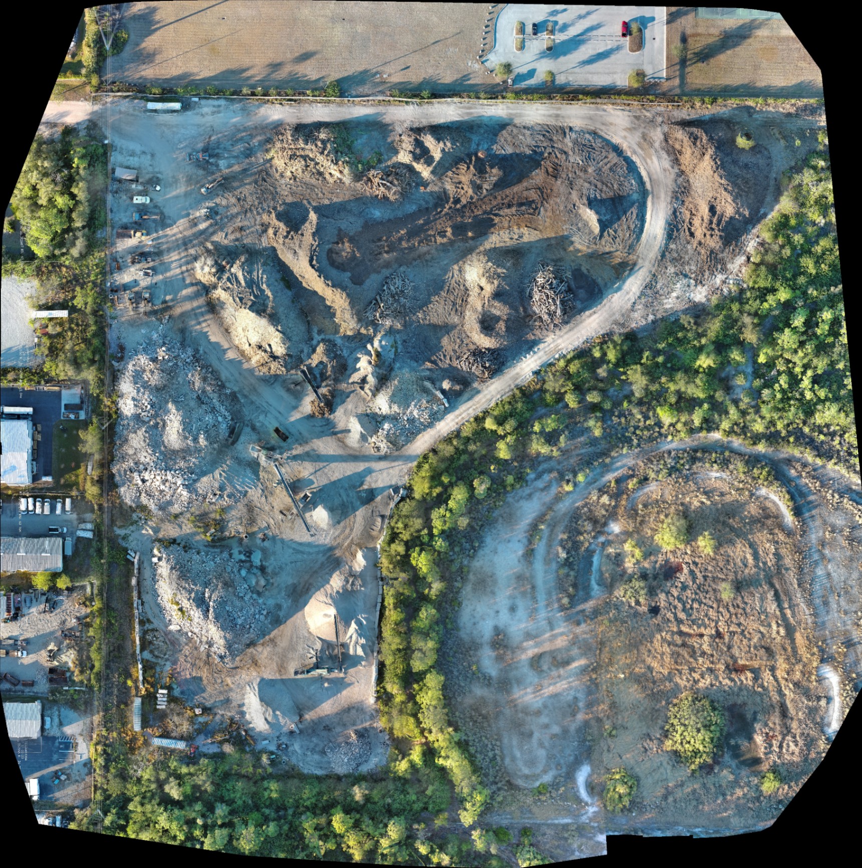
We use multi-pass flight plans that combine nadir and oblique imagery. This is essential for accurate volumetric analysis of soil stockpiles and detailed 3D modeling for land development.
9. Poor Post-Processing Workflows
Raw data is just the beginning. The way that data is processed determines the quality of the final deliverable. Using "quick-stitch" mobile apps often results in low-resolution outputs that lack the detail required for facility maintenance or engineering reviews.
The Pro Fix:
We use enterprise-grade photogrammetry software to process our imagery. This allows us to generate detailed Digital Surface Models (DSM) and high-resolution orthomosaics that provide a clear, bird’s-eye view of your entire project.
10. The "Pilot Only" Mentality
Flying a drone is the easy part. Understanding the science of remote sensing is what makes a professional. A pilot who doesn't understand thermal emissivity or GSD (Ground Sampling Distance) will deliver data that looks good but is fundamentally flawed.
The Pro Fix:
Cape UAV is led by expert pilots who understand the technical specs of our fleet. We don't just "fly and film": we capture data with the end-user in mind, whether that's a construction foreman or a property manager looking for energy inefficiencies.
Comparison: Professional vs. Amateur Drone Data
| Feature | Amateur/Consumer Drone | Cape UAV Enterprise Service |
|---|---|---|
| Visual Resolution | 12MP – 20MP | 50MP Visual |
| Thermal Sensor | None or Low-Res (160×120) | 640×512 (12um pitch) |
| Mapping Overlap | Inconsistent | 80/70 Standard |
| Processing | Automated Mobile Apps | High-Performance Photogrammetry |
| ROI | Visual reference only | Actionable data for planning |
The ROI of Precision Data
Investing in high-resolution drone data isn't a cost: it’s a savings strategy. By identifying a small roof leak via thermal imaging before it destroys the insulation, a property manager can save tens of thousands in repair costs. By using high-resolution orthomosaics to track construction progress, developers can avoid costly delays and ensure subcontractors are meeting deadlines.
In Southwest Florida, where the environment is harsh and the stakes for land development are high, precision is the only metric that matters.
Important Disclaimer
Mapping Disclaimer: Our data is for planning purposes and is not a substitute for a licensed land survey.
Thermal Disclaimer: Thermal results indicate anomalies and are not a substitute for evaluation by a licensed professional.
Ready to see the difference precision makes?
Whether you need thermal roof inspections or high-resolution mapping for land development, Cape UAV delivers the technical expertise Southwest Florida businesses trust.
Important Disclaimer
Mapping Disclaimer: Our data is for planning purposes and is not a substitute for a licensed land survey.
Thermal Disclaimer: Thermal results indicate anomalies and are not a substitute for evaluation by a licensed professional.