Commercial drone operations in Southwest Florida are no longer a novelty; they are a critical component of construction, facility maintenance, and luxury real estate marketing. When project managers in Cape Coral or Fort Myers hire drone subcontractors, they often treat the service as a commodity. This is a strategic error.
Subcontracting aerial data collection involves complex regulatory compliance, specialized hardware requirements, and data processing standards that go far beyond "flying a camera." Engaging the wrong partner doesn't just result in poor photos: it creates legal liability and data gaps that can derail a multimillion-dollar development.
1. Failing to Verify FAA Part 107 Certification
The most fundamental mistake is assuming every "pro" pilot is legally authorized to fly for your business. In the United States, any drone flight conducted for "furtherance of a business" requires the pilot to hold a valid FAA Part 107 Remote Pilot Certificate.
Why This Matters
Operating without a Part 107 certification is a federal violation. If an uncertified subcontractor crashes on your job site, your corporate insurance may deny the claim because the operation was illegal from the start. Furthermore, the FAA can levy heavy fines against both the operator and the company that hired them.
ROI Advantage
- Eliminates Legal Risk: Verified certification ensures the pilot understands airspace restrictions and safety protocols.
- Protects Insurance Coverage: Professional liability and hull insurance often hinge on the pilot’s legal standing.
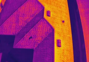
2. Settling for Low-Resolution Thermal Sensors
For facility maintenance and solar inspections, thermal imaging is the gold standard for detecting moisture intrusion or electrical hotspots. However, many subcontractors use consumer-grade thermal drones with low-resolution sensors (160×120 or 320×240 pixels).
At Cape UAV, we utilize the Autel Robotics EVO Lite 6T Enterprise (EVO Lite 640T). This platform features a 640×512 thermal sensor with a 12um pixel pitch. This technical specification is critical: it provides four times the detail of a 320-resolution sensor, allowing for the detection of minute temperature anomalies that cheaper equipment would miss.
The Technical Difference
| Feature | Consumer/Budget Drone | Cape UAV Enterprise Spec |
|---|---|---|
| Thermal Resolution | 160×120 or 320×240 | 640×512 |
| Pixel Pitch | 17um | 12um |
| Visual Camera | 12MP – 20MP | 50MP |
| Reliability | Intermittent Signal | Enterprise-grade Encryption/Stability |
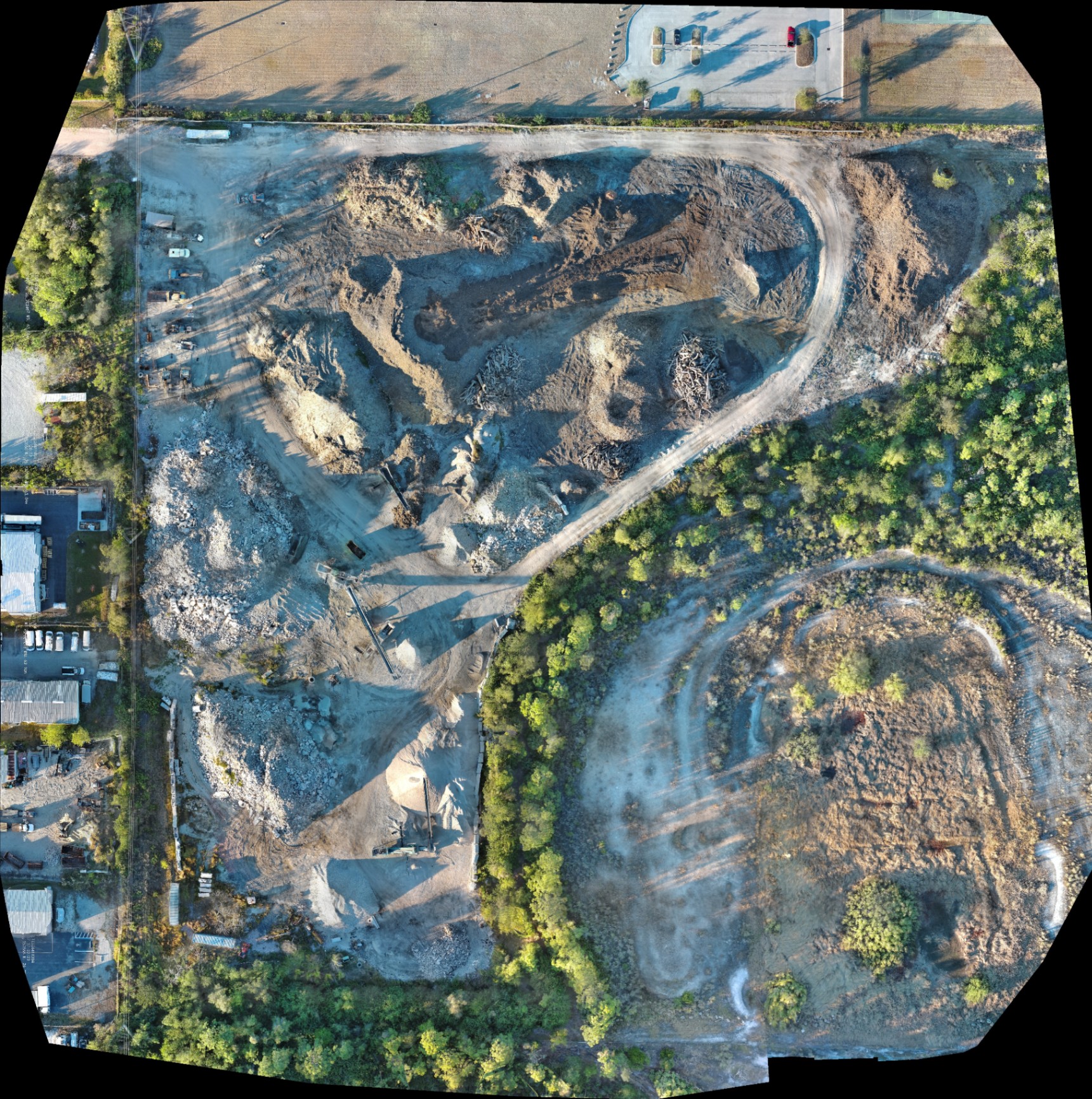
3. Ignoring the Specifics of Drone Mapping Deliverables
Hiring a subcontractor for "mapping" without specifying the deliverable is a recipe for project delays. There is a significant difference between a simple 2D orthomosaic and a high-density 3D model or a Digital Surface Model (DSM).
Why It Matters
If your engineering team needs a high-resolution drone orthomosaic to document site progress, but the subcontractor delivers a 3D mesh with warped textures, the data is useless for planning. You must define the Ground Sampling Distance (GSD) and the file format (GeoTIFF, .obj, .las) before the first flight.
ROI Advantage
- Saves Planning Time: High-resolution maps allow for remote site inspections, reducing the need for travel to the site.
- Improved Communication: Stakeholders can see the exact state of the project from any device.
4. Overlooking Data Management and Organization
A single drone mission for a construction site can generate several gigabytes of raw data. A common mistake is hiring a pilot who sends a massive, disorganized ZIP file via a transfer link that expires in seven days.
Professional subcontractors use structured folder systems and cloud-based hosting. Your data should be easily accessible, searchable, and formatted for integration into BIM (Building Information Modeling) or GIS software. Poor data management leads to lost files and the inability to compare site progress over time.
5. Neglecting Safety Protocols and Pre-Flight Checks
In the fast-paced environment of Southwest Florida construction, safety is often secondary to speed. If your subcontractor arrives on-site and launches immediately without conducting a safety briefing or checking local NOTAMs (Notices to Air Missions), they are a liability.
Why This Matters
A professional operation includes:
- Pre-flight Checklists: Verifying battery health, firmware status, and GPS signal.
- Site Clearance: Ensuring workers are aware of the flight path.
- Weather Monitoring: Drones should not operate in high winds or rain, which are common in Cape Coral.
6. Misunderstanding Thermal Capabilities (The "Magic Camera" Myth)
Many clients believe thermal cameras can "see through" walls or roofs. They cannot. Thermal sensors detect surface temperature variations. If your subcontractor doesn't understand the physics of emissivity and reflected temperature, they will misinterpret the data.
For example, in thermal roof inspections, a "hot spot" might simply be a reflective metal vent rather than a leak. You need a partner who understands how to calibrate the 640×512 sensor to the specific material being inspected to identify real anomalies.
ROI Advantage
- Identifies Hidden Risks: Detects moisture trapped under membranes before it causes structural rot.
- Supports Maintenance Planning: Focuses repair budgets on confirmed problem areas rather than entire roof replacements.
7. Using Informal "Gentleman’s Agreements"
Relying on a verbal agreement for drone services often leads to disputes over ownership of the raw footage, turnaround times, and liability. Every engagement should be backed by a clear Scope of Work (SOW).
What to Include in Your SOW:
- Equipment Minimums: Specifying enterprise-grade sensors (like the 50MP visual/640 thermal combo).
- Insurance Requirements: Evidence of at least $1M in aviation-specific liability insurance.
- Deliverable Timeline: When the processed orthomosaic vs 3D model will be delivered.
Comparison: Budget Pilot vs. Enterprise Partner
| Category | Budget Pilot (The Mistake) | Cape UAV (The Standard) |
|---|---|---|
| Equipment | Consumer-grade / Mini drones | Autel EVO Lite 6T Enterprise |
| Thermal Spec | 160×120 Resolution | 640×512 with 12um Pixel Pitch |
| Experience | Hobbyist with a permit | FAA Part 107 Professionals |
| Data Delivery | Disorganized cloud links | Structured, high-res deliverables |
| Compliance | Minimal / Unknown | Full transparency and documentation |
Strategic Value of Professional Drone Services
Choosing a technical expert like Cape UAV ensures that your aerial data is more than just a pretty picture. Whether it is documenting the progress of a land development project or identifying energy loss in an industrial facility, the quality of the data dictates the quality of your business decisions. High-resolution orthomosaics and 3D models provide the clarity needed to keep projects on schedule and under budget.
Important Disclaimer
Our data is for planning purposes and is not a substitute for a licensed land survey. Thermal results indicate anomalies and are not a substitute for evaluation by a licensed professional.
By avoiding these seven mistakes, you position your firm to capitalize on the massive ROI that drone technology offers. Don't settle for a pilot when you need a technical partner. Contact us today to discuss your next project in Cape Coral or Southwest Florida.
Important Disclaimer
Our data is for planning purposes and is not a substitute for a licensed land survey. Thermal results indicate anomalies and are not a substitute for evaluation by a licensed professional.