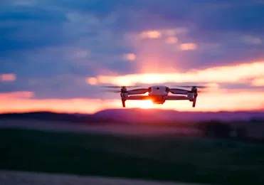
Hiring a drone service provider in Southwest Florida is no longer just about "getting a cool shot" from the air. For industries like construction, property management, and luxury real estate, aerial data is a high-stakes technical investment. Whether you are documenting a $10M waterfront estate in Cape Coral or conducting a thermal inspection on a commercial roof, the quality of the data determines the ROI of the project.
Unfortunately, many businesses treat drone services as a commodity, leading to expensive legal risks, unusable data, and missed deadlines. To protect your investment, you must move beyond the "guy with a drone" mentality and hire for technical proficiency.
Here are the seven critical mistakes businesses make when hiring drone services and how to avoid them.
1. Hiring Pilots Without FAA Part 107 Certification
The most significant risk any business can take is hiring an unlicensed operator. Since 2016, the FAA has required all commercial drone pilots to hold a Part 107 Remote Pilot Certificate. This isn't a suggestion: it is Federal law.
Why This Matters:
If you hire an unlicensed pilot and an incident occurs, your company can be held liable. The FAA has the authority to issue "cease and desist" orders and significant fines to both the operator and the entity that hired them. A Part 107 certification ensures the pilot understands airspace regulations, weather patterns, and emergency procedures.
How to Avoid It:
Request a digital or physical copy of the pilot’s FAA Remote Pilot Certificate before any work begins. At Cape UAV, all missions are conducted by FAA Part 107–certified pilots who prioritize safety and legal compliance.
2. Prioritizing Price Over Technical Specifications
In the drone industry, you truly get what you pay for. Choosing the lowest bid often means you are hiring someone using consumer-grade equipment with small sensors and limited dynamic range.
Technical Reality:
For industrial inspections and high-end real estate, sensor size is everything. A consumer drone might capture a 12MP image, but an enterprise platform like the Autel Robotics EVO Lite 6T Enterprise (also known as the EVO Lite 640T) utilizes a 50MP visual camera and a dedicated thermal sensor.
ROI Advantage:
High-resolution visuals mean you can zoom into 3D models or orthomosaics without losing clarity. This allows project managers to identify a cracked tile or a misaligned beam without being physically present on-site.
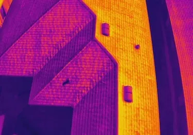
3. Misunderstanding Thermal Imaging Requirements
Thermal imaging is one of the most misunderstood services in the drone industry. Many providers offer "thermal" using low-resolution sensors that produce "blurry" heat maps. For facility maintenance or solar inspections, low-res data is practically useless.
Technical Spec to Look For:
Look for a 640×512 thermal resolution and a 12um pixel pitch. The 12um (micrometer) pixel pitch refers to the distance between the centers of the pixels on the sensor. A smaller pixel pitch allows for higher spatial resolution, meaning the drone can detect smaller temperature anomalies from a greater height.
| Feature | Consumer Thermal | Cape UAV Enterprise Thermal |
|---|---|---|
| Resolution | 160×120 or 320×240 | 640×512 |
| Pixel Pitch | 17um+ | 12um |
| Data Quality | Indistinct heat blobs | Precise anomaly detection |
Why This Matters:
In a commercial roof inspection, a 12um sensor can identify trapped moisture or insulation failures that a lower-grade sensor would miss entirely.
4. Confusing Mapping Deliverables with "Survey-Grade" Work
This is a legal and technical minefield. Many drone companies claim to provide "survey-grade" maps. Unless that company is led by a licensed Land Surveyor, these claims are often inaccurate and potentially illegal depending on state regulations.
The Solution:
Understand that drone mapping (photogrammetry) is an incredible tool for planning, volume calculations, and progress tracking, but it is not a boundary survey. At Cape UAV, we provide high-resolution orthomosaics and 3D models that give construction teams a comprehensive view of their site, helping to reduce rework and streamline logistics.
Why This Matters:
Using a drone map to determine property lines for a legal dispute without a licensed surveyor is a recipe for disaster. Use drone data for what it’s best at: visual documentation and project management.

5. Failing to Verify Insurance and Liability Coverage
A standard general liability insurance policy often excludes "aviation" or "aircraft" operations. If a drone crashes into a luxury home or an industrial transformer, and the operator only has standard business insurance, you are exposed.
How to Avoid It:
Ensure your drone service provider carries a specific drone liability policy (often $1M to $5M depending on the project). This protects your assets and provides peace of mind when operating over high-value properties or active construction sites.
6. Overlooking Post-Production and Data Integration
The drone flight is only 20% of the job. The real value lies in how that data is processed. Many providers will hand over a folder of raw images and expect you to figure it out.
What You Should Receive:
- For Real Estate: Edited, high-dynamic-range (HDR) photos that highlight the luxury features of a property.
- For Construction: Processed orthomosaics or 3D models compatible with Procore, Autodesk, or other BIM software.
- For Thermal: Detailed reports highlighting specific anomalies with temperature data.
Without professional processing, you are just looking at pictures, not actionable data.
7. Neglecting Local Knowledge and Airspace Expertise
Hiring a national "pilot network" often results in an out-of-town operator who doesn't understand the specific challenges of Southwest Florida. From the heavy humidity affecting thermal readings to the complex airspace around Page Field or Southwest Florida International (RSW), local expertise is vital.
Why This Matters:
A local provider like Cape UAV knows how to navigate local LAANC (Low Altitude Authorization and Notification Capability) requirements and understands the best times of day to capture the high-contrast lighting required for luxury real estate photography in Cape Coral.
Summary: Hiring for Value, Not Just Visuals
When you hire for drone services, you are hiring a technical partner. The goal is to gain clarity, reduce risk, and save money. By avoiding these seven mistakes, you ensure that your aerial data supports your business goals rather than creating new liabilities.
Important Disclaimer
Mapping Disclaimer: Our data is for planning purposes and is not a substitute for a licensed land survey.
Thermal Disclaimer: Thermal results indicate anomalies and are not a substitute for evaluation by a licensed professional.
Important Disclaimer
Autel Robotics is a trademark of its respective owner; Cape UAV is not affiliated with or endorsed by Autel Robotics. Our mapping data is intended for project monitoring and planning; it is not a substitute for a licensed land survey. Thermal results indicate heat anomalies and are not a substitute for evaluation by a licensed professional. Results depend on environmental conditions.
If you are ready to integrate professional, technical drone data into your next project, contact us today to discuss your specific needs. From high-resolution thermal imaging to precision drone mapping, we provide the technical expertise Southwest Florida businesses rely on.