Traditional site planning has long relied on two-dimensional blueprints and static CAD files to guide development. While these tools provide a foundational layout, they often fail to capture the dynamic reality of a physical jobsite: leading to unforeseen delays and budget overruns.
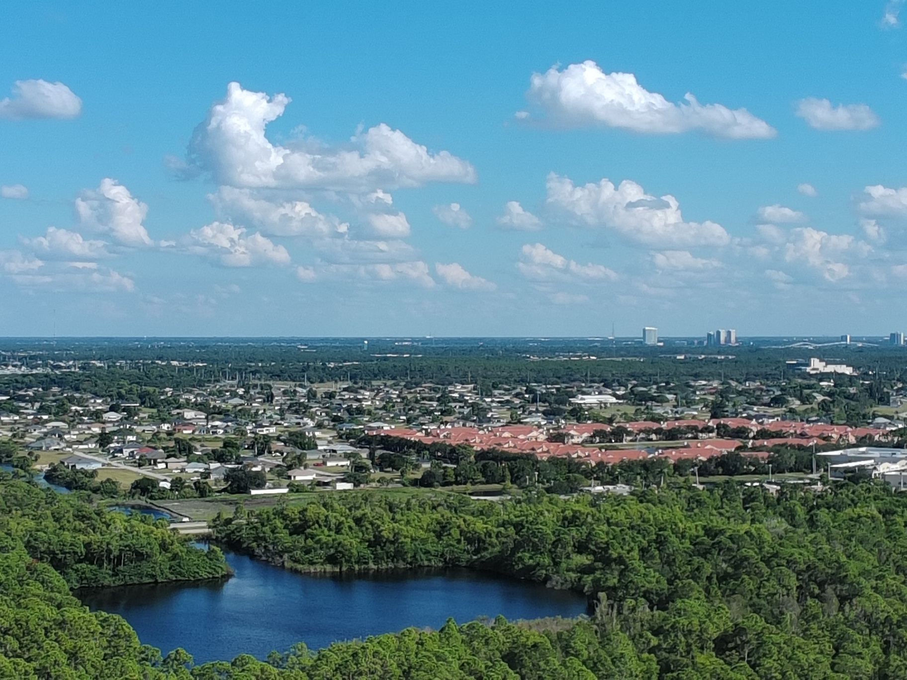
In the rapidly expanding landscapes of Cape Coral, Fort Myers, and Naples, the margin for error in land development is increasingly slim. 3D drone modeling introduces a digital twin approach that bridges the gap between design intent and field reality.
By utilizing high-resolution aerial data, developers can now identify efficiency gaps early in the project lifecycle. This proactive identification ensures that resources are allocated effectively and stakeholders remain aligned through immersive visualization.
The Digital Twin: A New Standard for Southwest Florida Development
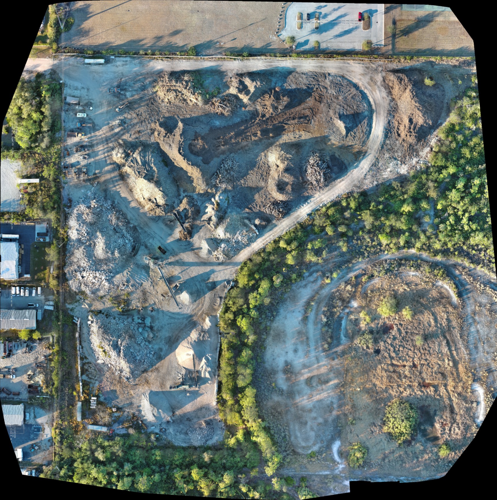
A digital twin is a high-fidelity 3D representation of a physical site, captured through systematic aerial photogrammetry. Unlike a static map, this model allows for interactive rotation, zooming, and analysis of every square foot of a property.
For architects and site planners in Southwest Florida, this technology offers a level of site context that traditional methods cannot replicate. It provides a comprehensive view of elevation changes, existing vegetation, and surrounding infrastructure: all within a single digital environment.
Integrating 3D models into the early stages of site planning allows teams to simulate various scenarios. This capability is essential for managing the unique drainage and environmental requirements common in Lee and Collier Counties.
Enterprise Hardware: The Autel EVO Lite 640T Advantage
The quality of a 3D model is directly dependent on the sensor used to capture the initial imagery. At Cape UAV, we utilize the Autel Robotics EVO Lite 6T Enterprise (EVO Lite 640T) to ensure the highest level of data clarity.
This platform features a 50MP visual camera capable of capturing intricate textures and fine details across large-scale developments. These high-resolution images are the building blocks for creating immersive 3D models that look and feel like the actual site.
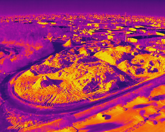
Additionally, the 640×512 thermal sensor provides a secondary layer of data for site analysis. Thermal imaging helps identify anomalies such as hidden moisture pockets or subsurface temperature variations: providing insights that support site management and safety.
Identifying Efficiency Gaps through Plan-to-Field Verification
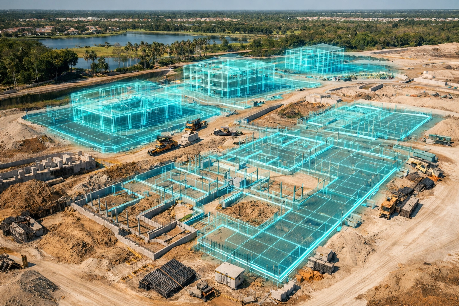
One of the most significant advantages of 3D modeling is the ability to perform plan-to-field verification. By overlaying design blueprints onto a 3D digital twin, planners can immediately see where actual site conditions diverge from the original plan.
These discrepancies: often referred to as efficiency gaps: can range from minor layout errors to significant elevation conflicts. Identifying these issues before vertical construction begins prevents costly rework and change orders.
Common efficiency gaps identified through drone modeling include:
- Site Coordination Errors: Detecting conflicts between different trades or equipment placement before they disrupt the workflow.
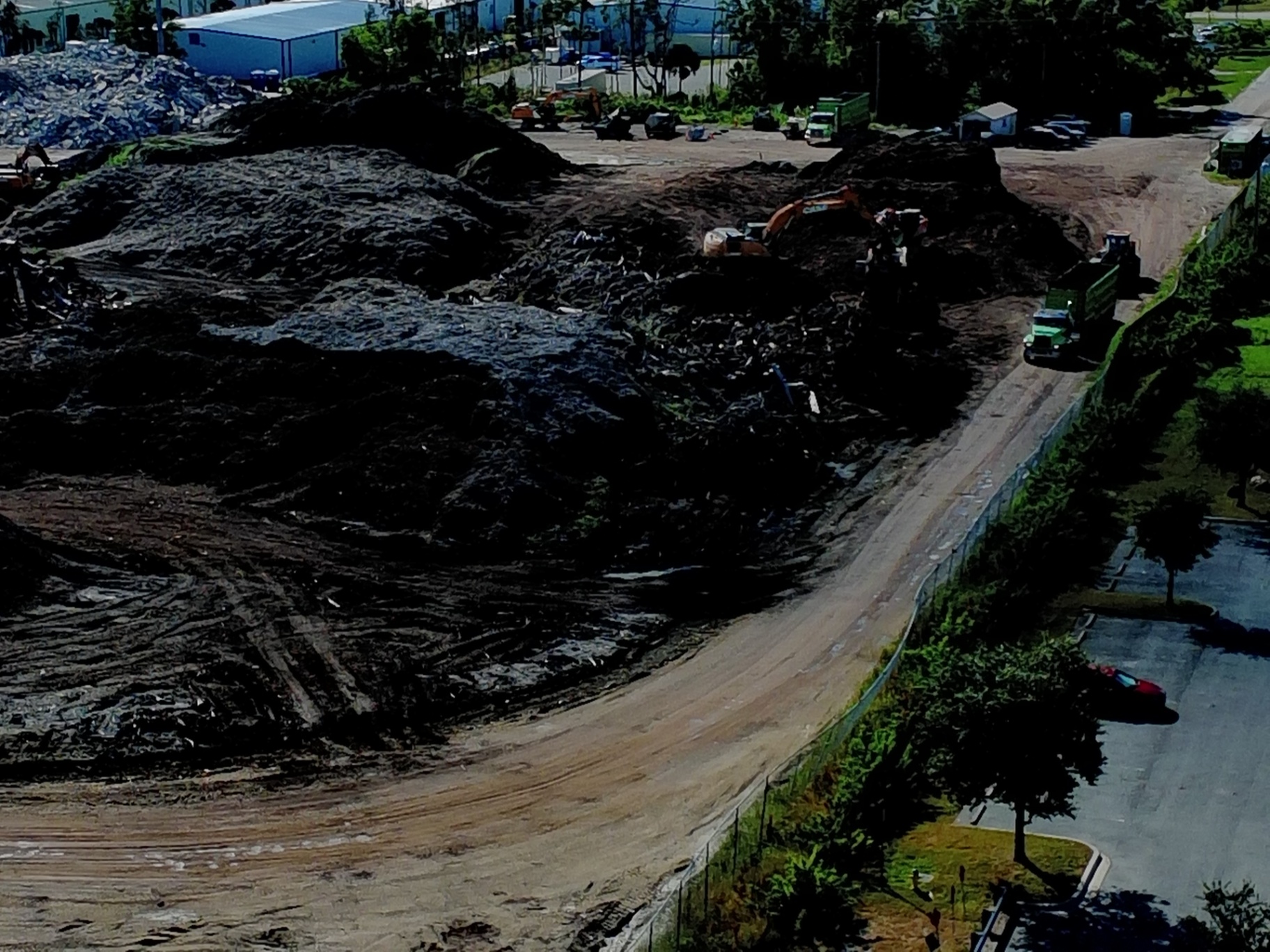
- Material Management: Verifying the exact location and volume of stockpiles to prevent over-ordering or logistics bottlenecks.
- Logistics Hazards: Identifying potential obstructions for heavy machinery, such as cranes or haul trucks, that are not visible on 2D plans.
ROI of Immersive 3D Visualization for Stakeholders
Beyond the technical benefits, 3D drone modeling serves as a powerful communication tool for stakeholders and investors. Immersive visualization allows non-technical partners to experience the site in a way that 2D blueprints simply do not allow.
For pre-sale marketing in high-end markets like Naples and Fort Myers, these models provide a competitive edge. Prospective buyers and investors can view a "future-state" model of the development, increasing confidence and accelerating decision-making.
The ROI of this visualization is found in reduced meeting times and fewer Requests for Information (RFIs). When everyone can see the same 3D reality, clarity replaces confusion: ensuring that projects move forward without the friction of misinterpretation.
Advanced Site Analysis: Volumetrics and Drainage
In Southwest Florida, water management and earthworks are among the most critical components of any land development project. 3D modeling allows for precise volumetric analysis of soil, gravel, and debris piles across a site.
This data enables site planners to track material movement with high frequency. Knowing exactly how much fill is on-site or how much more is needed helps keep budgets on track and prevents project stalls.
Furthermore, the 3D model provides a detailed look at the site’s topography. Planners can identify opportunities for efficiency in drainage design by analyzing the natural flow of water across the digital twin: ensuring compliance with local environmental regulations.
Enhancing Safety and Compliance with Thermal Integration
Safety is a primary concern on any active jobsite, and drone modeling contributes significantly to risk mitigation. The 3D model allows safety officers to conduct virtual site walks, identifying hazards without entering dangerous areas.
The thermal capabilities of the Autel EVO Lite 640T add another dimension to site safety. By detecting heat signatures, the drone can identify overheating equipment or electrical anomalies that might pose a fire risk.
These thermal results indicate anomalies and are not a substitute for evaluation by a licensed professional: but they serve as a critical early warning system. Integrating this data into the 3D model provides a holistic view of site health and safety compliance.
Comparison: Traditional 2D Plans vs. 3D Digital Twins
| Feature | Traditional 2D Plans | 3D Drone Modeling |
|---|---|---|
| Perspective | Static, overhead only | Immersive, 360-degree |
| Detail Level | Symbolic/Schematic | Photo-realistic textures |
| Site Context | Limited to property lines | Includes surrounding infrastructure |
| Communication | Requires technical interpretation | Intuitive for all stakeholders |
| Update Frequency | Usually static throughout phase | Easily updated with weekly flights |
| Error Detection | Manual and time-consuming | Automated plan-to-field overlays |
Supporting Long-Term Project Success in SWFL
The adoption of 3D modeling is not just about the current project phase: it is an investment in the entire lifecycle of the asset. The digital twin created during site planning can be used for ongoing progress monitoring and eventual facility management.
For developers in Cape Coral and the surrounding areas, this means having a permanent, high-resolution record of what was built and where it was placed. This documentation is invaluable for future renovations, maintenance, or property sales.
By moving beyond the blueprint, local developers gain the clarity, confidence, and control needed to navigate complex site conditions. 3D modeling identifies the hidden gaps that traditional methods overlook: ensuring that every project starts with a foundation of accurate, actionable data.
ROI Advantage: The Bottom Line
The financial benefits of 3D drone modeling are clear when considering the costs of project delays. A single identified conflict in the site planning phase can save tens of thousands of dollars in avoided rework and equipment downtime.
Using high-resolution imagery to support site analysis allows for more accurate bidding and resource allocation. This data-driven approach minimizes waste and ensures that projects stay within budget: protecting the developer’s bottom line from the start.
Ultimately, the transition to 3D visualization is about reducing risk. In an industry where time is money, the ability to see the future of a site before a single shovel hits the ground is the ultimate efficiency.
Important Disclaimer
Mapping Disclaimer: Our data is for planning purposes and is not a substitute for a licensed land survey.
Thermal Disclaimer: Thermal results indicate anomalies and are not a substitute for evaluation by a licensed professional.
Important Disclaimer
Autel Robotics is a trademark of its respective owner; Cape UAV is not affiliated with or endorsed by Autel Robotics. Drone flight results depend on environmental conditions and specific site requirements. All data provided is for planning and documentation purposes only.
Important Disclaimer
Our data is for planning purposes and is not a substitute for a licensed land survey. Thermal results indicate anomalies and are not a substitute for evaluation by a licensed professional.