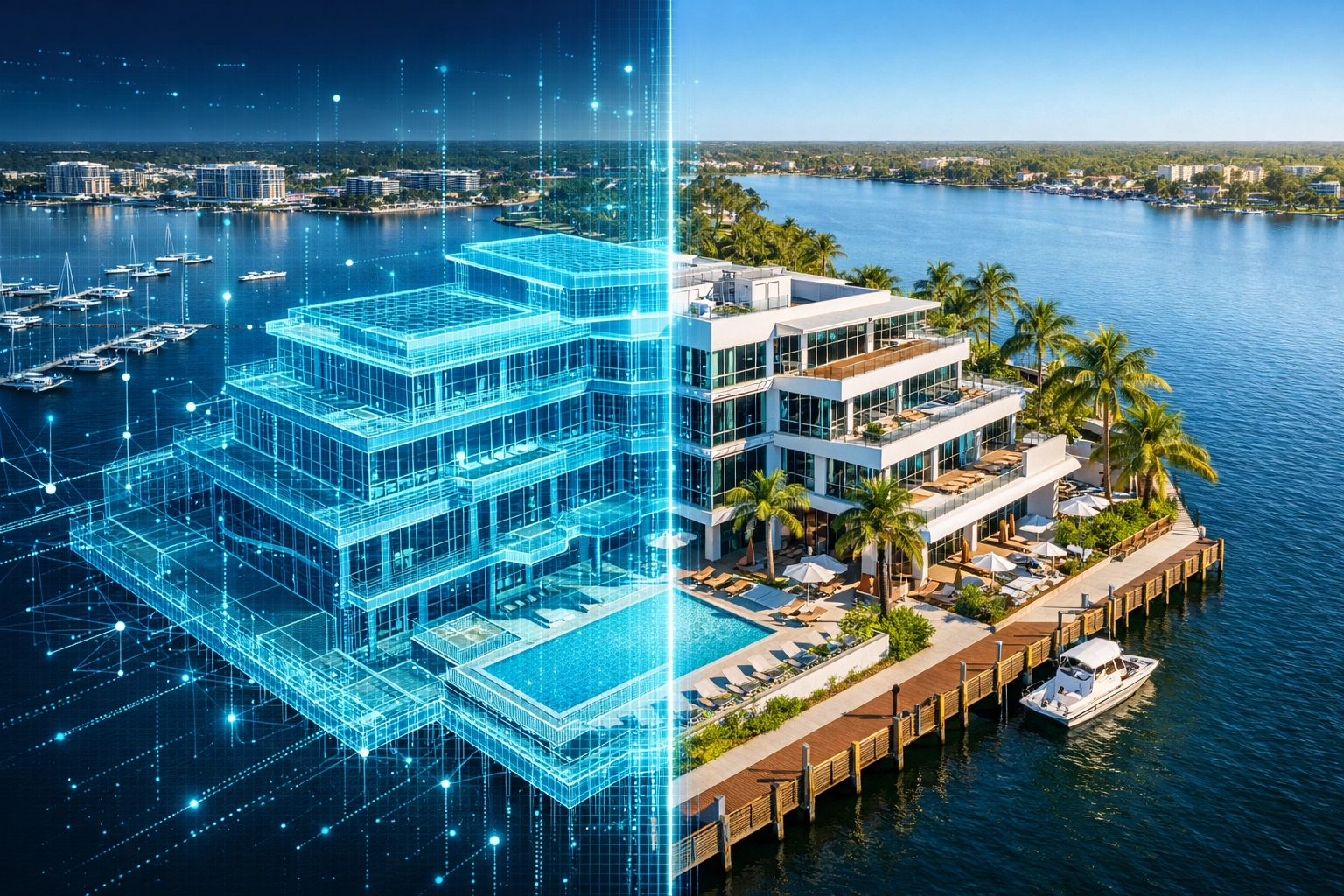
Digital twins are virtual replicas of physical properties, generated through high-resolution aerial data and sophisticated photogrammetry. For property managers in Southwest Florida, this technology represents a shift from reactive repairs to proactive asset preservation. In a region where salt air, high humidity, and intense storm seasons accelerate building degradation, the ability to "walk" a site virtually via a 3D model offers a competitive advantage in both maintenance and stakeholder communication.
By utilizing enterprise-grade drones, Cape UAV provides property managers with comprehensive digital documentation that serves as a permanent record of site conditions. This isn't just about high-quality photography; it is about creating an immersive, dimensionally accurate environment for planning, inspection, and facility management.
The Shift to Digital Site Documentation
Traditional property management often relies on manual inspections, handheld photography, and outdated blueprints. These methods are fragmented and prone to human error. A digital twin centralizes all physical data into a single, navigable 3D interface.
Why It Matters
- Complete Visual Context: Unlike a series of 2D photos, a 3D model allows you to view the property from any angle, providing context for how different systems: such as roofing, drainage, and HVAC: interact.
- Historical Baselines: By capturing a digital twin annually or semi-annually, managers can track structural changes or wear patterns over time.
- Remote Accessibility: Stakeholders, owners, or contractors can inspect a site in Cape Coral or Fort Myers from anywhere in the world, reducing travel costs and accelerating decision-making.
Precision Hardware: The Autel Robotics EVO Lite 6T Enterprise
The quality of a digital twin is dictated by the sensors used to capture the data. Cape UAV utilizes the Autel Robotics EVO Lite 6T Enterprise (EVO Lite 640T) to deliver high-resolution mapping deliverables. This platform is equipped with a 50MP visual camera and a 640×512 thermal sensor, allowing for the simultaneous capture of visual and thermal data.
Technical Specifications and Capabilities
- 50MP Visual Sensor: High-pixel density ensures that when you zoom into the 3D model, textures: such as cracks in stucco or rust on mechanical mounts: remain sharp and identifiable.
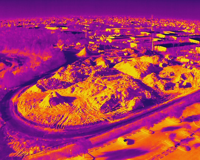
- 640×512 Thermal Sensor: Essential for identifying "invisible" issues. Integrating thermal data into a 3D workflow reveals heat anomalies in electrical panels or moisture intrusion in roofing systems before they become catastrophic failures.
- FAA Part 107 Compliance: All missions are executed by certified pilots, ensuring that data collection is not only precise but also adheres to all federal and local aviation regulations.
Note: Autel Robotics is a trademark of its respective owner; Cape UAV is not affiliated with or endorsed by Autel Robotics. Results depend on environmental and flight conditions.
Strategic Applications for SWFL Property Managers
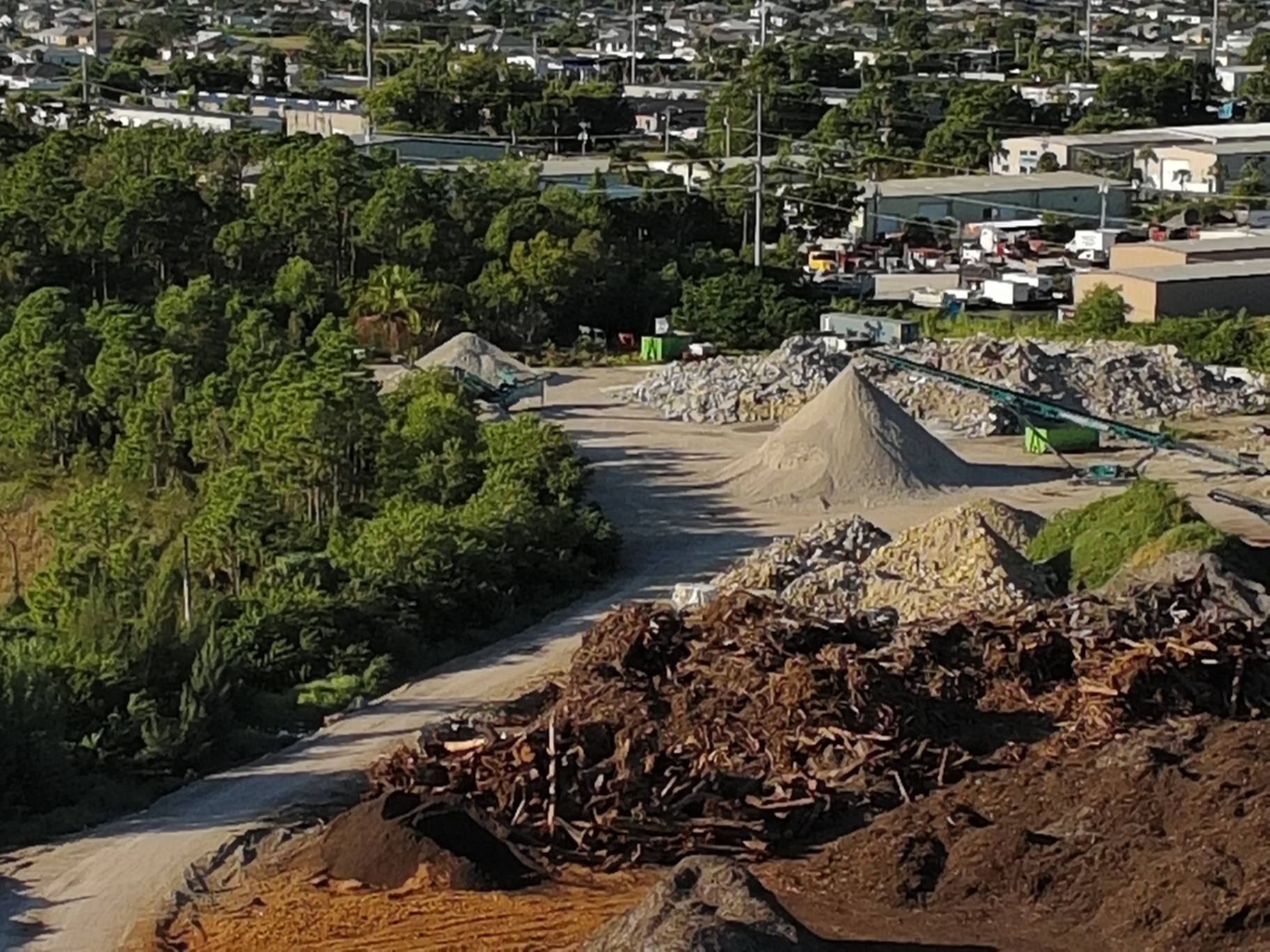
Southwest Florida presents unique challenges for facility maintenance. From the industrial corridors of Cape Coral to expansive residential HOAs, 3D modeling streamlines complex workflows.
1. Hurricane Preparedness and Recovery
A digital twin captured before hurricane season provides an indisputable record of "pre-loss" conditions. If a storm impacts the region, a second flight can be conducted to generate a "post-loss" model. This side-by-side comparison simplifies insurance claims and provides contractors with precise visual data for repair estimates.
2. Roof and Building Envelope Inspections
Inspecting multi-story buildings or large industrial warehouses traditionally requires ladders, lifts, or scaffolding. Drone-based 3D modeling eliminates these safety risks.
Why This Matters
Property managers can identify ponding water on flat roofs, damaged flashing, or failing sealants from their desks. When combined with thermal imaging, the model reveals subsurface moisture that is invisible to the naked eye, allowing for targeted repairs instead of full roof replacements.
3. Contractor Coordination and Bidding
When soliciting bids for painting, paving, or roofing, providing contractors with a 3D digital twin ensures everyone is bidding on the same data. Contractors can virtually measure the surface area of a facade or the linear footage of a parking lot within the model. This transparency reduces "change orders" and ensures more accurate project budgeting.
Comparison: Traditional vs. 3D Drone-Led Management
| Feature | Traditional Inspection | 3D Digital Twin (Drone) |
|---|---|---|
| Safety | High risk (climbing, heights) | Zero-risk (ground-based operation) |
| Data Continuity | Fragmented (random photos) | Unified (complete 3D mesh) |
| Inspection Speed | Days/Weeks | Hours |
| Visibility | Visual only | Visual + Thermal (dual-sensor) |
| Record Keeping | Physical files/2D folders | Cloud-based 3D archive |
ROI Advantage: The Financial Case for 3D Modeling
Investing in 3D drone models is not just a technological upgrade; it is a financial strategy. The ROI is realized through three primary channels:
1. Avoided Catastrophes
Early detection of a roof leak via thermal-integrated 3D models can save a property owner tens of thousands of dollars in interior water damage and mold remediation. Finding a $500 problem today prevents a $50,000 failure tomorrow.
2. Reduced On-Site Time
By providing contractors and engineers with a digital twin, the number of physical site visits is drastically reduced. This streamlines the project lifecycle and lowers the billable hours typically spent on manual site documentation.
3. Enhanced Tenant Retention
For commercial and industrial properties, proactive maintenance means fewer disruptions. When tenants see a property manager utilizing advanced technology like drone mapping, it signals a commitment to professional, high-standard facility care.
Integrating 3D Models into Your Workflow
Getting started with digital twins does not require a massive infrastructure overhaul. Cape UAV provides deliverables in formats that are compatible with standard facility management software and web browsers.
- Site Capture: We deploy the EVO Lite 6T to capture thousands of high-overlap images.
- Processing: Using advanced photogrammetry, we process the images into a high-density point cloud and a textured 3D mesh.
- Delivery: The model is hosted on a secure platform where you can rotate, zoom, and annotate specific areas of interest.
For property managers overseeing industrial sites or large-scale developments, this level of detail is transformative. It provides a "single source of truth" for the entire management team.
Important Disclaimer
Mapping Disclaimer: Cape UAV provides aerial data and imaging services. We are not licensed land surveyors or professional engineers. Our data is for planning and documentation purposes and is not a substitute for a licensed land survey or for engineering design without verification by a licensed professional in those respective fields.
Thermal Disclaimer: Thermal results indicate anomalies and are not a substitute for evaluation by a licensed professional.
The Future is Virtual
As Southwest Florida continues to grow, the complexity of managing properties increases. 3D modeling and digital twins offer a way to scale management efforts without sacrificing detail or safety. By leveraging the precision of the Autel EVO Lite 6T and the expertise of FAA-certified pilots, property managers can ensure their assets are documented, protected, and maintained with the highest degree of professionalism.
Whether you are managing a single commercial asset in Cape Coral or a portfolio across SWFL, the clarity provided by 3D drone models is the new standard for excellence.
Ready to see your property from a new perspective?
Explore our drone services or view our FAQ to learn more about how we can support your facility maintenance goals.
Important Disclaimer
Cape UAV provides aerial data and imaging services. We are not licensed land surveyors or professional engineers. All mapping data is for informational/planning purposes and should not be used as a legal survey or for engineering design without verification by a licensed professional in those respective fields. Thermal results indicate anomalies and are not a substitute for evaluation by a licensed professional.