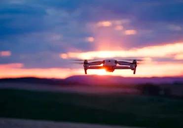
In the world of modern business, drones have shifted from high-tech toys to essential enterprise tools. Whether you are managing a multi-million dollar construction site in Cape Coral or listing a luxury waterfront estate, aerial data provides a perspective that was once impossible: or at least incredibly expensive: to obtain.
However, as drones become more accessible, a common question arises: "My nephew has a drone; can’t he just take the photos for me?"
The short answer is no. The long answer involves federal law, massive liability risks, and a significant gap in data quality. If you are using a drone to further a business interest, the Federal Aviation Administration (FAA) requires the operator to hold a Part 107 Remote Pilot Certificate.
Here is the truth about why hiring a certified professional isn't just a "nice to have": it is a critical requirement for protecting your business and ensuring the ROI of your aerial missions.
The Legal Reality: It’s Not a Suggestion, It’s Federal Law
The FAA is very clear on this: any drone flight conducted for "furtherance of a business" requires a Part 107 certification. This isn't limited to selling the photos themselves. If you use a drone to inspect your own roof, monitor a job site you manage, or enhance a real estate listing, you are operating commercially.
Why It Matters
Operating without a license isn't just a minor technicality. The FAA has the authority to issue significant fines to both the pilot and the person or company that hired them. In 2026, the regulatory environment is stricter than ever. With Remote ID requirements and increased airspace monitoring, flying "under the radar" is no longer a viable strategy.
When you hire Cape UAV, you are hiring pilots who have mastered the FAA’s Aeronautical Knowledge Test. We understand airspace classifications, weather patterns, and emergency procedures. We handle the paperwork, the LAANC (Low Altitude Authorization and Notification Capability) approvals, and the risk assessments so you don't have to.
Liability and Risk Mitigation: Protecting Your Assets
Aerial operations inherently involve risk. Even the most advanced drones can face mechanical failures, unexpected wind gusts, or bird strikes.
The Liability Gap
If an uncertified hobbyist crashes a drone into a client’s luxury SUV or, worse, causes an injury on a construction site, your standard business insurance likely won't cover the damages. Most insurance providers explicitly exclude "aviation-related" incidents unless the operator is properly licensed and following federal regulations.
Why This Matters:
- Professional Indemnity: Certified pilots carry specialized drone liability insurance.
- Safety Protocols: Part 107 pilots follow strict pre-flight checklists and maintenance schedules.
- Asset Protection: We use enterprise-grade equipment designed for reliability in demanding environments.
ROI Advantage
By hiring a professional, you eliminate the catastrophic financial risk of an uninsured accident. One avoided legal battle pays for years of professional drone services.
Enterprise Hardware vs. Consumer Toys
There is a massive hardware gap between the drone you buy at a big-box retailer and the equipment we use at Cape UAV. For our core services: including thermal imaging and precision mapping: we utilize the Autel Robotics EVO Lite 6T Enterprise (EVO Lite 640T).
Technical Specs That Drive Results
When we talk about "high resolution," we aren't just using a buzzword. Our equipment features:
- 50MP Visual Camera: Provides incredible clarity for luxury real estate and detailed asset inspections.
- 640×512 Thermal Sensor: Essential for detecting heat signatures that the naked eye simply cannot see.
- 12um Pixel Pitch: This technical specification is critical. A smaller pixel pitch allows for higher thermal resolution and better temperature accuracy, which is vital for solar farm inspections and facility maintenance.
Note: Autel Robotics is a trademark of its respective owner; Cape UAV is not affiliated with or endorsed by Autel Robotics. Equipment results depend on environmental conditions.
Thermal Imaging: Seeing the Invisible
One of the most significant advantages of hiring a Part 107 professional is access to advanced thermal sensors. In Southwest Florida, thermal imaging is a game-changer for property managers and facility directors.
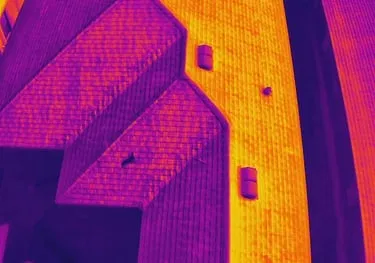
Why 12um Pixel Pitch and 640 Resolution Matter
Many entry-level "thermal" drones use low-resolution sensors that provide "blurry" heat maps. Our 640×512 sensor, combined with a 12um pixel pitch, delivers the precision needed to identify:
- Moisture Intrusion: Identifying trapped water under flat commercial roofs before it causes structural damage.
- Electrical Faults: Finding "hot spots" in solar panels or electrical substations that indicate imminent failure.
- Energy Inefficiency: Identifying areas of heat loss in HVAC systems or building envelopes.
ROI Advantage
Proactive thermal inspections can save tens of thousands of dollars in emergency repairs. By identifying a leak or a failing electrical component early, you transition from reactive "crisis management" to proactive, planned maintenance.
Precision Mapping and 3D Modeling
For construction and land development, a simple photo isn't enough. You need data that helps you plan, track progress, and communicate with stakeholders. Cape UAV provides high-resolution orthomosaic maps and 3D models that offer a comprehensive view of your project.
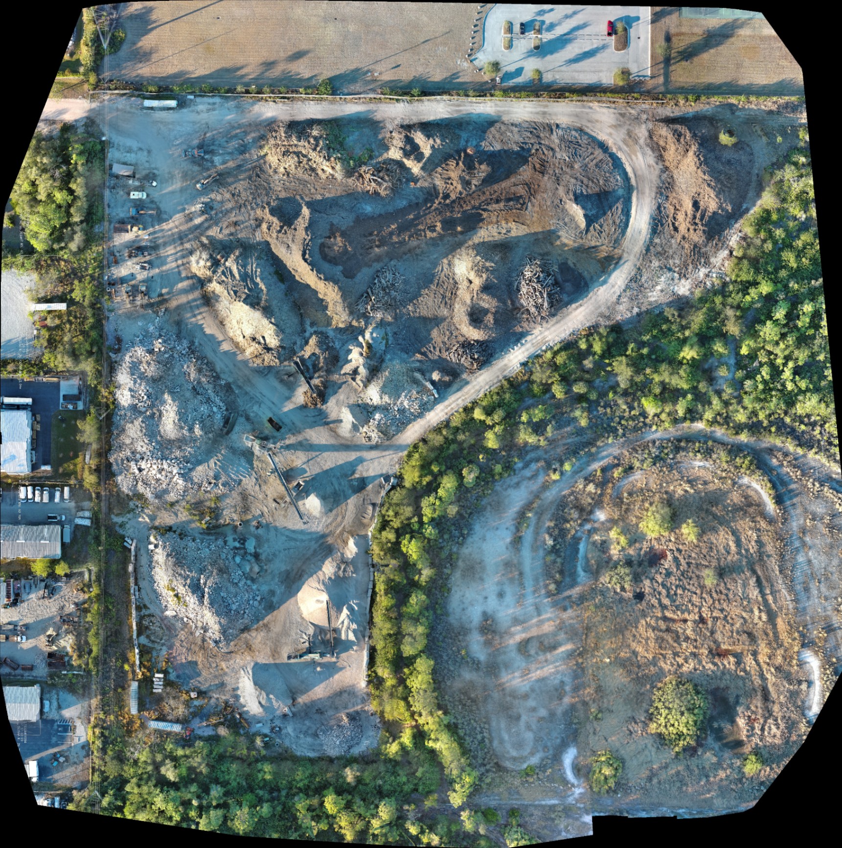
Beyond the Snapshot
A professional mapping pilot doesn't just "take a picture." We fly automated, overlapping grids to capture hundreds of data points, which are then processed into a single, high-definition orthomosaic.
How This Supports Your Project:
- Site Planning: Get a clear, updated view of current site conditions.
- Progress Documentation: Provide investors and stakeholders with visual proof of milestones.
- Volumetric Analysis: Assist in monitoring stockpiles and earth-moving progress (for planning purposes).
ROI Advantage
Traditional ground-based site walks are time-consuming and offer a limited perspective. A drone can map a 50-acre site in a fraction of the time, delivering a digital twin that your entire team can access from their desktops. This eliminates travel time and speeds up the decision-making process.
Luxury Real Estate: The 50MP Difference
In the competitive Southwest Florida real estate market, visual storytelling is everything. High-end buyers expect more than just "aerial shots": they expect a cinematic experience that highlights the lifestyle and the location.
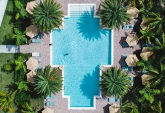
The Professional Edge in Photography
With a 50MP visual camera, we capture details that standard drones miss. We don't just show the house; we highlight the texture of the landscaping, the clarity of the pool, and the proximity to the Gulf.
Why This Matters:
- Dynamic Range: Our sensors handle the harsh Florida sun, preserving detail in both shadows and highlights.
- Perspective: We understand the "hero angles" that make a property look grand rather than flat.
- Compliance: We ensure that flights near neighbors or in restricted airspaces are handled legally and respectfully.
The Cost of "Cheap" Drone Services
When you choose a drone provider based solely on the lowest price, you are often sacrificing more than just image quality. You are sacrificing:
- Legality: The risk of FAA fines.
- Safety: The lack of formal risk mitigation and insurance.
- Data Integrity: Low-resolution sensors that provide "pretty pictures" but zero actionable data.
- Professionalism: A pilot who doesn't understand the nuances of a construction site or the privacy concerns of a luxury neighborhood.
At Cape UAV, we position ourselves as your technical partner. We aren't just pilots; we are data providers who understand the specific needs of the B2B sector in Cape Coral and the surrounding areas.
Final Thoughts: Clarity, Confidence, and Control
Hiring an FAA Part 107 certified pilot is the only way to ensure your drone operations are legal, safe, and effective. Whether it’s identifying a thermal anomaly on a commercial roof using a 12um pixel pitch sensor or creating a high-resolution map for a new land development project, the professional approach always delivers the highest ROI.
Don't leave your business's reputation and safety to chance. Partner with experts who have the certifications, the enterprise-grade hardware, and the local expertise to get the job done right.
Important Disclaimer
Mapping Disclaimer: Our data is for planning purposes and is not a substitute for a licensed land survey.
Thermal Disclaimer: Thermal results indicate anomalies and are not a substitute for evaluation by a licensed professional.
Ready to see what professional drone services can do for your next project?
Explore our Drone Services or Contact Us today for a consultation.
Important Disclaimer
- Mapping: All mapping deliverables, including orthomosaics and 3D models, are intended for planning and documentation purposes only. Cape UAV does not provide licensed land surveying services.
- Thermal: Thermal imaging identifies temperature anomalies. These results are indicators of potential issues and should be verified by a licensed contractor or professional in the relevant field (e.g., HVAC, electrical, or roofing).