When you hire a drone service provider for your luxury real estate listing, construction site, or industrial facility in Southwest Florida, you aren’t just paying for "cool photos." You are investing in data, efficiency, and: most importantly: regulatory compliance. In the United States, commercial drone operations are governed by the Federal Aviation Administration (FAA) under Part 107.
Failure to follow these rules doesn't just risk a fine for the pilot; it can create significant liability for the property owner or project manager who hired them. At Cape UAV, we prioritize safety and technical precision to ensure every mission is executed within the legal framework while delivering high-impact results.
Here are the five critical aspects of FAA Part 107 safety you need to know before booking your next aerial mission.
1. Commercial Operations Require a Remote Pilot Certificate
The first thing to understand is the line between a hobbyist and a professional. If any money, services, or "value" changes hands in exchange for drone work, the operation is commercial. This requires the pilot to hold an FAA Remote Pilot Certificate.
To earn this certificate, a pilot must pass a comprehensive 60-question exam. This isn't a simple "how to fly" test. It covers:
- Airspace Classifications: Knowing where we can and cannot fly without authorization.
- Aviation Weather: Understanding density altitude, microbursts, and how heat affects lift.
- Radio Communications: Monitoring local airport frequencies to ensure separation from manned aircraft.
- Aeronautical Decision Making (ADM): Identifying risks before they become accidents.
Why This Matters
Hiring an uncertified pilot is more than a gamble: it's a liability. Professional pilots at Cape UAV maintain their currency and follow strict pre-flight checklists to ensure the safety of your assets and personnel.
ROI Advantage: Working with certified professionals ensures that your project data is legally defensible and that your business is protected from the fallout of unauthorized operations.
2. Altitude and Speed Restrictions Are Non-Negotiable
FAA Part 107 sets clear physical boundaries for drone flight. Under standard regulations, drones are restricted to a maximum altitude of 400 feet above ground level (AGL) and a maximum groundspeed of 100 miles per hour.
In the context of construction and land development in Cape Coral or Fort Myers, these limits are vital. While 400 feet is the standard ceiling, there is a technical exception: if a pilot is inspecting a structure (like a cell tower or a high-rise building), they can fly up to 400 feet above the topmost point of that structure, provided they remain within a 400-foot radius of it.

Why This Matters
These limits prevent collisions with manned aircraft, particularly helicopters and small planes that may be flying at low altitudes. Any service provider claiming they can fly "as high as you want" to get a better view is likely operating outside the law.
ROI Advantage: Controlled, low-altitude flights result in higher ground sampling distance (GSD). For our mapping services, staying within these limits ensures the high-resolution detail required for accurate 3D modeling and site planning.
3. Advanced Equipment and Technical Specifications
Safety isn't just about rules; it’s about the technology used to follow them. At Cape UAV, our primary enterprise platform is the Autel Robotics EVO Lite 6T Enterprise (EVO Lite 640T). This is not a consumer toy; it is a high-performance tool designed for industrial applications.
Technical specs that drive safety and results include:
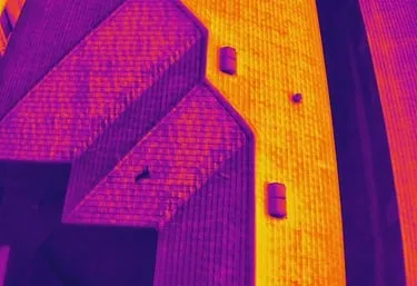
- Thermal Capability: A 640×512 thermal sensor with a 12um pixel pitch. This allows us to identify thermal anomalies in facility maintenance or solar inspections from a safe distance.
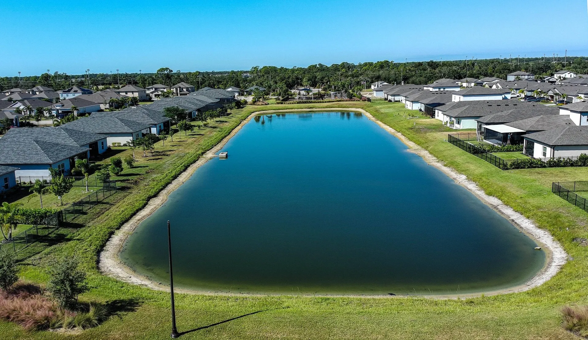
- Visual Precision: A 50MP visual camera for high-resolution aerial photography that captures every detail of a luxury real estate property.
- Obstacle Avoidance: Multi-directional sensors that help prevent collisions in complex environments like construction sites or densely landscaped neighborhoods.
Note: Autel Robotics is a trademark of its respective owner; Cape UAV is not affiliated with or endorsed by Autel Robotics.
Why This Matters
High-end sensors like the 12um thermal pitch on our EVO Lite 6T allow for "detect-and-avoid" levels of detail. We can identify a failing electrical component or a roof leak without having to hover inches away from the structure, significantly reducing the risk of a "prop strike" or equipment failure.
ROI Advantage: Higher resolution means more data per flight. You get better insights in less time, reducing the number of site visits required.
4. Visual Line of Sight (VLOS) and Airspace Authorization
A critical safety pillar of Part 107 is that the pilot: or a designated visual observer: must maintain visual line of sight with the drone at all times. This means the pilot must be able to see the aircraft’s location, altitude, and orientation without the aid of binoculars or FPV goggles.
Furthermore, much of Southwest Florida is located near airports (like RSW or Page Field). Flying in these "controlled" airspaces requires prior FAA authorization. We utilize the Low Altitude Authorization and Notification Capability (LAANC) system to get near-instant approval for flights in these areas.
Why This Matters
Maintaining VLOS ensures the pilot can react to sudden changes, such as a bird strike or an approaching low-flying helicopter. If a provider offers to "fly five miles out" to capture a coastline, they are violating VLOS rules and endangering the airspace.
ROI Advantage: Using LAANC and professional flight planning tools allows Cape UAV to operate in complex locations where others might be grounded, ensuring your project stays on schedule regardless of proximity to an airport.
5. Strict Regulations for Operations Over People
One of the most complex areas of Part 107 involves flying over people. The FAA has established four categories of drones that can operate over people, based primarily on the risk of injury if the drone were to fall.
- Category 1: Drones weighing less than 0.55 lbs (250g) with no exposed rotating parts.
- Categories 2-4: Heavier drones that must meet specific safety certifications and kinetic energy impact limits.
For most enterprise-level work involving drones like the Autel EVO Lite 6T, we follow "transient" flight rules or work within closed-set environments (like active construction sites where all personnel are briefed and under cover).
Why This Matters
In luxury real estate or community marketing, flying over a crowded pool area or a neighborhood event requires specific equipment and protocols. We ensure that our flight paths are designed to minimize risk to the public while still capturing the stunning vistas your property deserves.
ROI Advantage: Safe flight planning avoids the catastrophic costs of accidents and the potential legal entanglements that follow. It provides peace of mind for property managers and homeowners alike.
Technical Comparison: Why Enterprise Equipment Wins
| Feature | Consumer Drone | Cape UAV Enterprise (EVO Lite 6T) |
|---|---|---|
| Thermal Resolution | None or Low-Res | 640×512 (Professional Grade) |
| Thermal Pixel Pitch | N/A | 12um (High Sensitivity) |
| Visual Resolution | 12MP – 20MP | 50MP |
| Wind Resistance | Low | High (Up to Level 7) |
| Reliability | Variable | Enterprise Redundancy |
The Cape UAV Approach to Safety and Results
Safety is the foundation, but the data is the goal. Whether we are producing high-resolution orthomosaics for a land development project or conducting a thermal inspection for facility maintenance, we approach every mission with a "safety first" mindset.
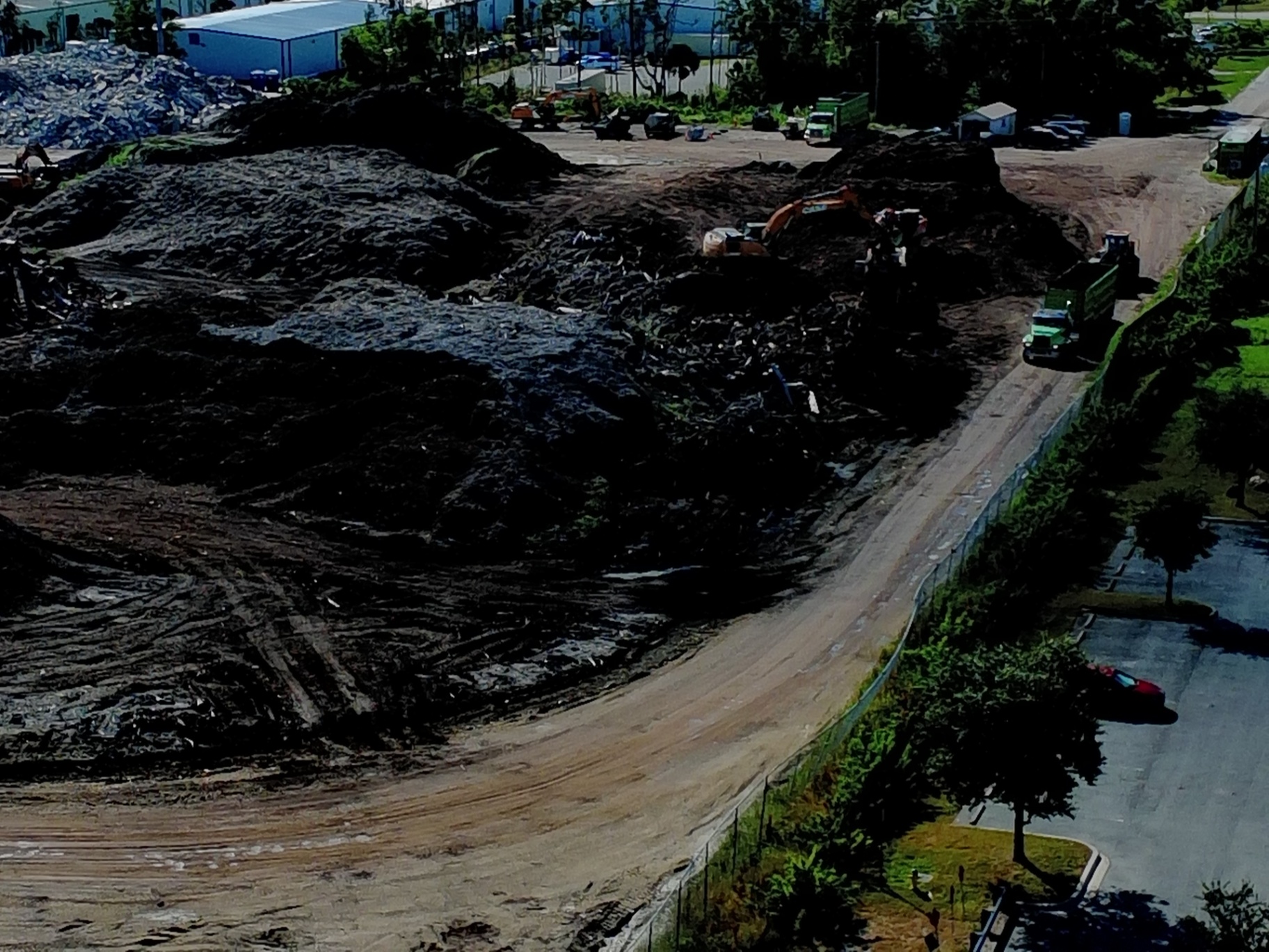
Our precision drone mapping and 3D modeling services allow construction teams to track progress with incredible detail. By documenting site conditions from the air, you can identify material movement, monitor equipment placement, and keep stakeholders informed: all while staying compliant with FAA regulations.
ROI of Professional Safety
When you hire Cape UAV, you are hiring technical experts who understand the nuances of Florida airspace and the physics of aerial imaging. We provide:
- Risk Mitigation: Full compliance with Part 107 reduces your corporate liability.
- Technical Excellence: 12um thermal sensors and 50MP visual cameras for "best-in-class" data.
- Efficiency: Faster inspections and mapping workflows that save thousands in manual labor and potential errors.
Important Disclaimer:
Mapping Disclaimer: Our data is for planning purposes and is not a substitute for a licensed land survey.
Thermal Disclaimer: Thermal results indicate anomalies and are not a substitute for evaluation by a licensed professional.
Ready to see the difference that professional, safe, and technical drone services can make for your project? From luxury real estate in Cape Coral to industrial inspections across Southwest Florida, Cape UAV is your partner in aerial excellence.
Explore our Drone Services | Contact Us for a Quote
Important Disclaimer
Thermal results indicate anomalies and are not a substitute for evaluation by a licensed professional. Our data is for planning purposes and is not a substitute for a licensed land survey.