When project managers request "drone mapping," they're often unaware they're asking for three fundamentally different deliverables: each with distinct capabilities, accuracy levels, and use cases. Choosing the wrong format wastes money, delays timelines, and produces data that doesn't answer your project's critical questions.
Understanding the technical differences between traditional 2D maps, orthomosaic mapping, and 3D drone mapping determines whether your aerial data becomes a decision-making tool or an expensive image file.
What Traditional 2D Maps Actually Deliver (And Why They're Obsolete for Modern Projects)
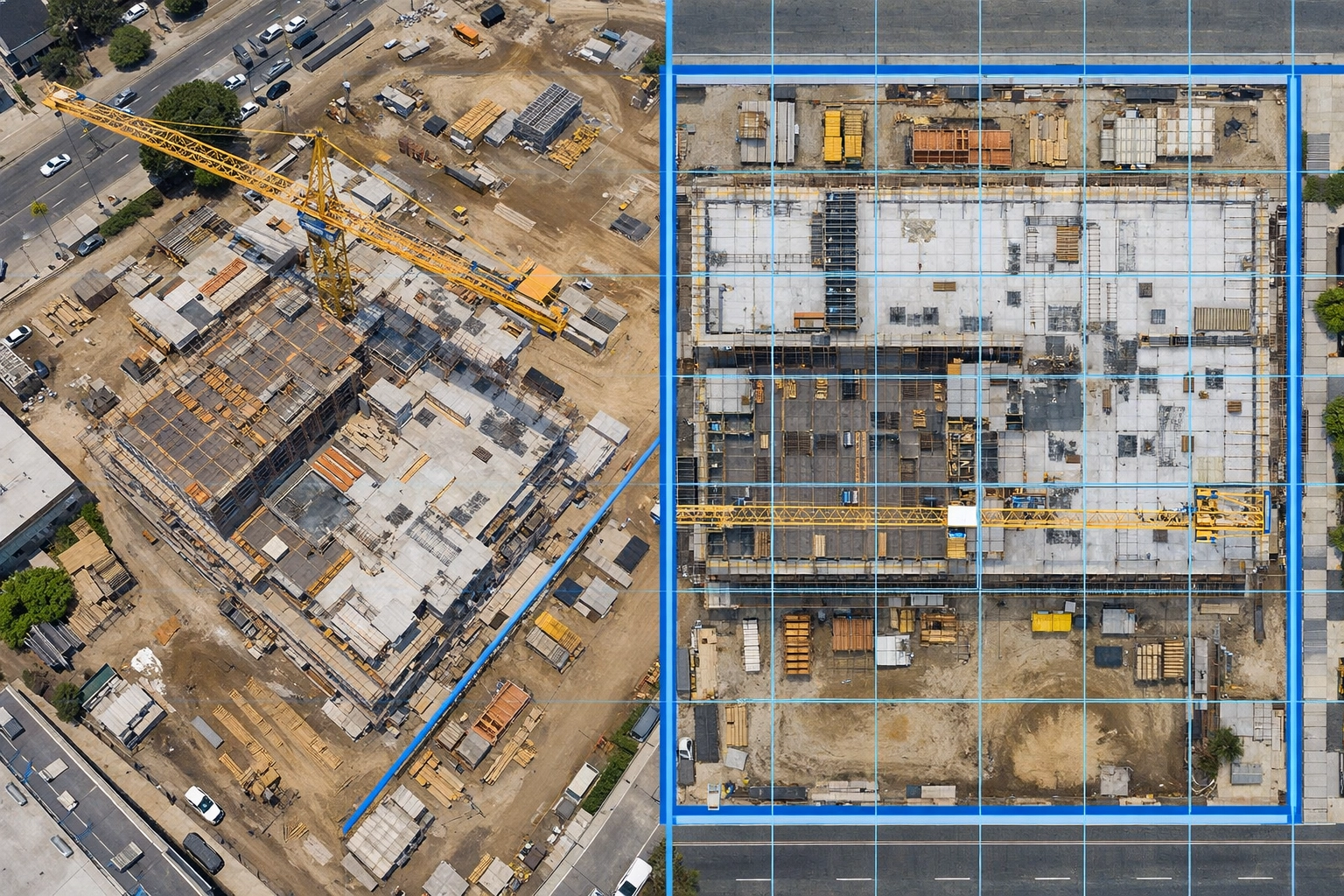
Traditional 2D aerial maps are standard photographs taken from above: nothing more. They capture what the camera sees from a specific angle, complete with perspective distortion, lens tilt effects, and inconsistent scale across the image.
These images cannot provide accurate measurements. A building in the foreground appears larger than an identical structure in the background due to perspective distortion. Distance calculations are unreliable because scale varies across different portions of the photograph.
Why This Matters: If your project requires measuring stockpile volumes, tracking construction progress against plans, or calculating acreage, traditional 2D maps fail to deliver usable data. They're suitable only for basic visual reference: not surveying, planning, or analysis.
Orthomosaic Mapping: The Foundation of Precision Aerial Data
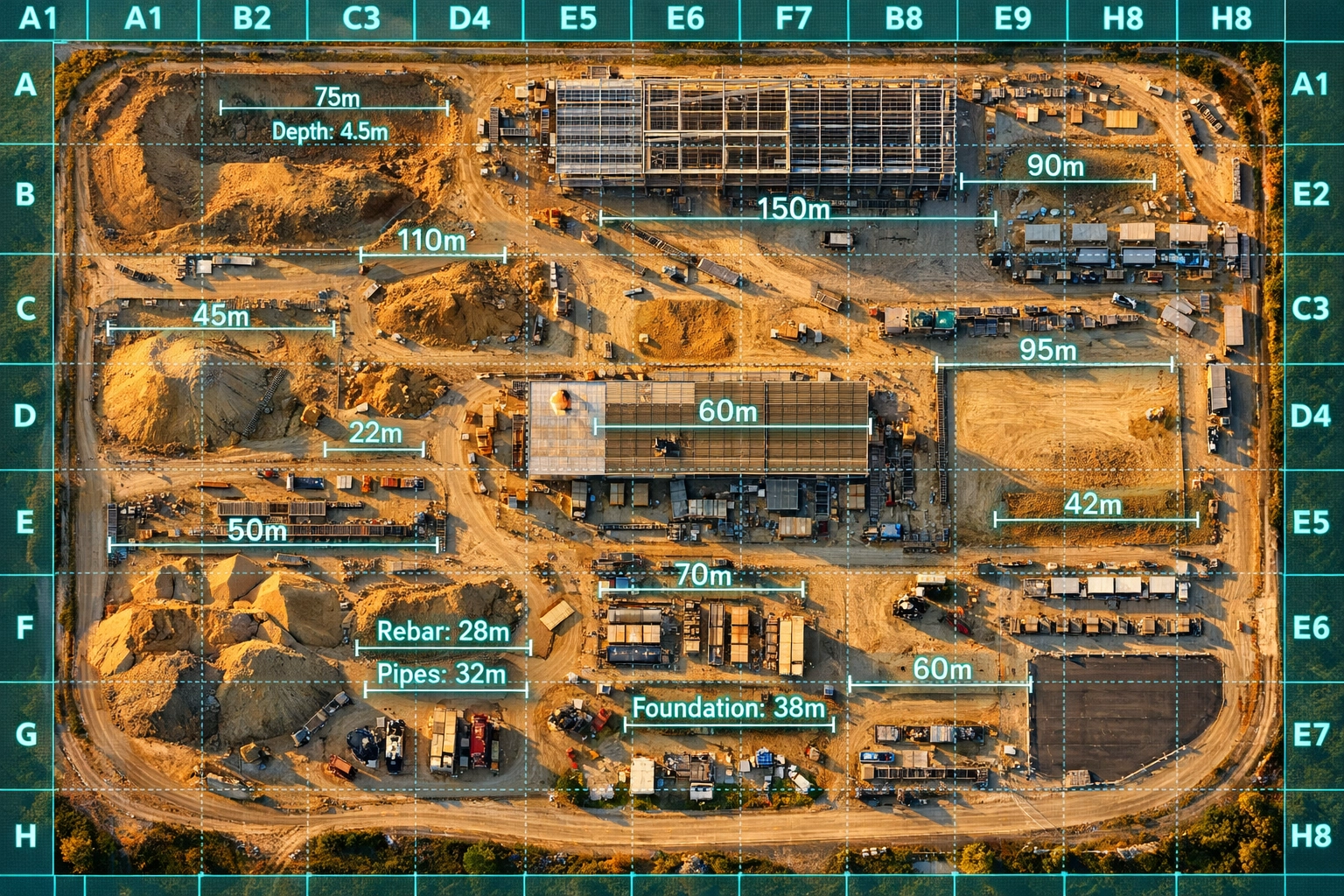
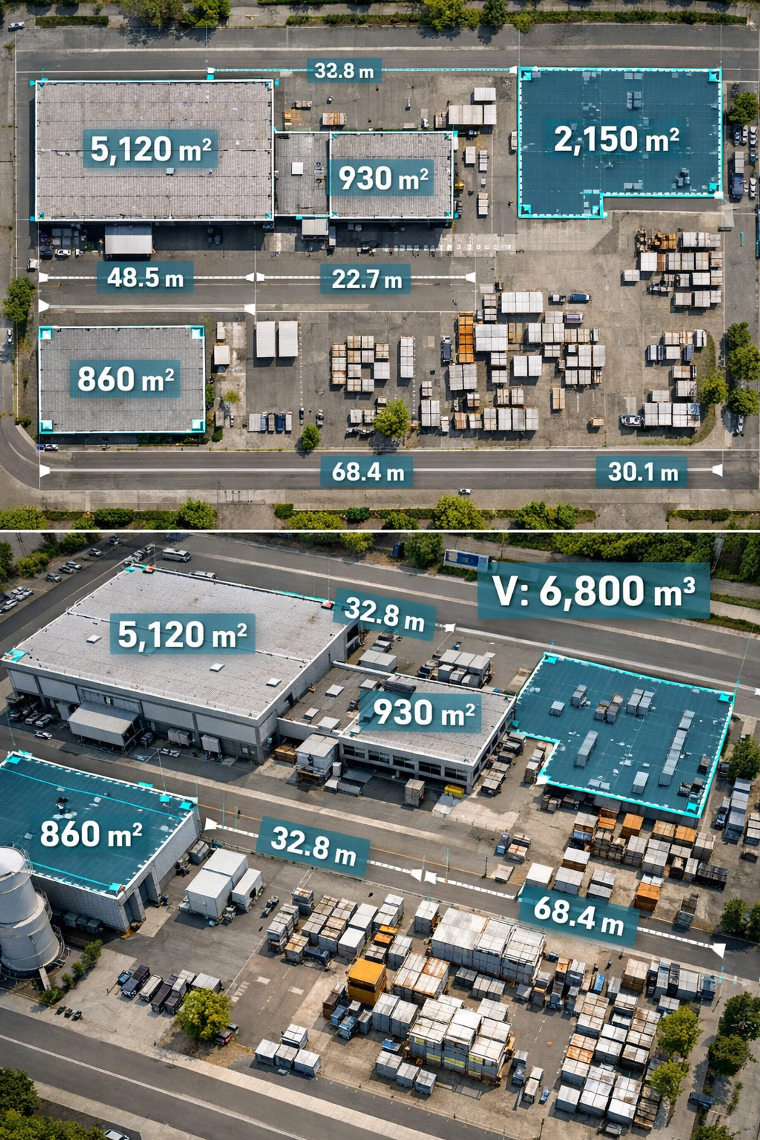
An orthomosaic is a geometrically corrected aerial image created by stitching hundreds of overlapping photographs and applying orthorectification: a process that removes perspective distortion, corrects for camera tilt, and adjusts for terrain elevation. The result is a seamless, top-down image with uniform scale across the entire survey area.
Orthomosaics deliver centimeter-level accuracy, transforming aerial imagery from visual reference into survey-grade data. Every pixel corresponds to a precise real-world location, enabling accurate distance measurements, area calculations, and overlay comparisons with CAD drawings or GIS data.
When Orthomosaic Mapping Is Essential
Construction projects rely on orthomosaics for site planning, cut-and-fill calculations, progress documentation, and as-built surveys. The uniform scale allows project teams to measure distances, verify grading work, and compare current conditions against design plans: all from a single, comprehensive image.
Land management and environmental monitoring benefit from the ability to track changes over time with precision. Orthomosaics captured quarterly or annually reveal vegetation encroachment, erosion patterns, and land use changes with measurable accuracy.
Disaster response and damage assessment require the speed and comprehensive coverage that only drone-based orthomosaics provide. Traditional ground surveys take weeks; orthomosaics deliver complete site documentation in hours.
ROI Advantage: A single orthomosaic replaces dozens of site visits, eliminates the need for expensive manned aircraft surveys, and provides documentation that answers questions months after the flight: without returning to the site.
3D Drone Mapping: When Your Project Needs Elevation and Spatial Context
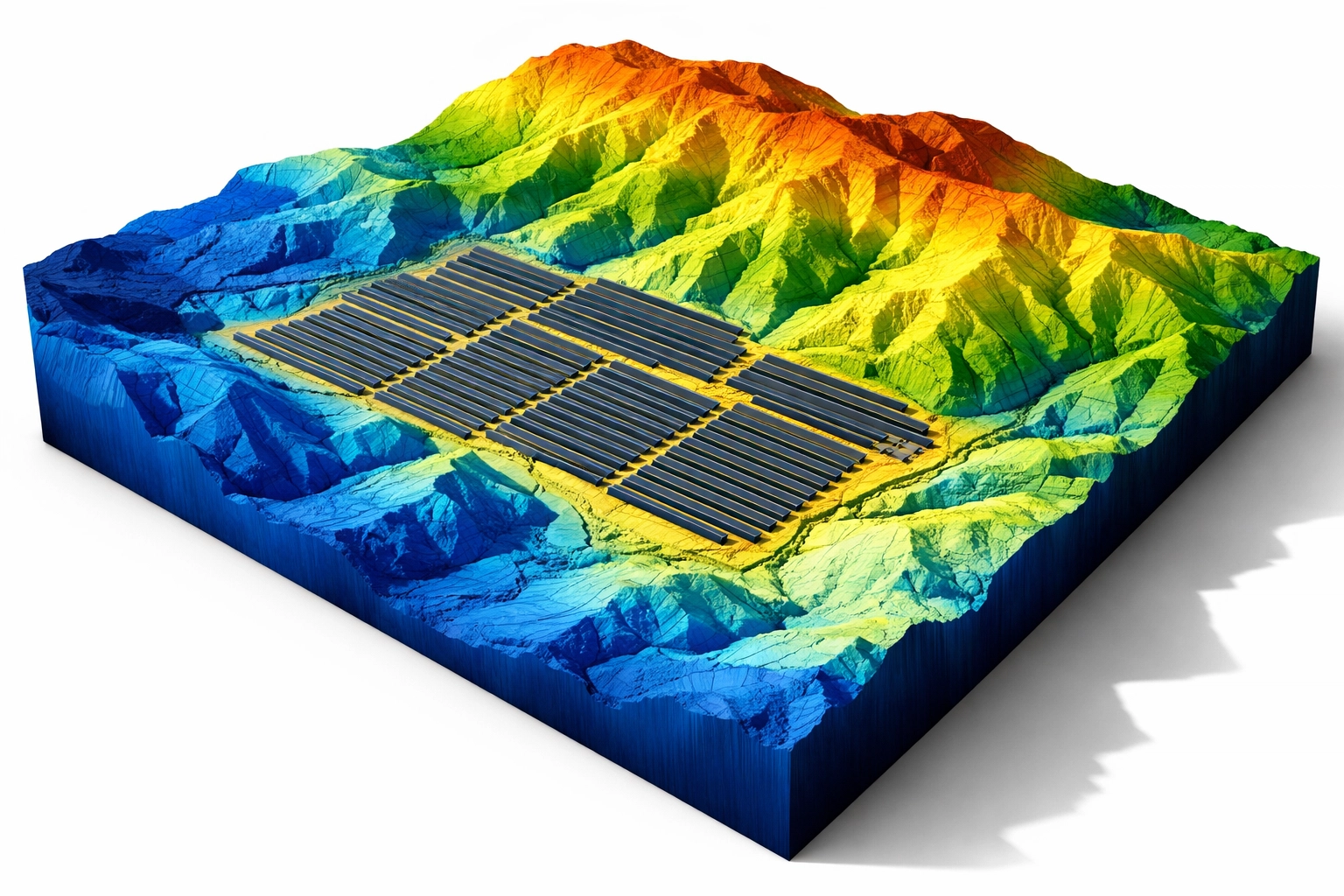
While orthomosaics provide precise 2D information, 3D models add the critical third dimension: elevation data that reveals topography, volume, and spatial relationships. Generated through photogrammetry, 3D drone mapping creates detailed digital reconstructions of physical environments with measurable vertical accuracy.
These models include Digital Surface Models (DSM), Digital Elevation Models (DEM), and fully textured 3D meshes that can be explored from any angle. Every point in the model contains X, Y, and Z coordinates, enabling volumetric calculations, slope analysis, and line-of-sight studies impossible with 2D data alone.
Applications That Demand 3D Models
Stockpile volume measurement is where 3D models excel. Calculate precise volumes of gravel piles, excavation sites, or material storage areas without ground-based surveying. Track inventory changes over time with accuracy that directly impacts cost accounting and project billing.
Solar site assessment requires shading analysis throughout the day and across seasons. 3D models reveal how buildings, trees, and terrain features cast shadows on proposed panel locations: information invisible in 2D orthomosaics.
Infrastructure inspection and facade analysis benefit from photorealistic, to-scale visualization. Inspect bridge structures, building exteriors, and telecommunications towers from any angle without physically accessing dangerous locations.
Terrain and drainage analysis for civil engineering projects depends on elevation data. Identify water flow patterns, calculate earthwork volumes, and plan drainage systems based on accurate topographic information.
Why This Matters: 3D models provide complete site context with granular obstruction detection. They answer "what if" questions about sight lines, sun exposure, and spatial relationships that orthomosaics cannot address.
Direct Comparison: Matching Deliverables to Project Requirements
| Deliverable Type | Accuracy Level | Best For | Primary Limitation |
|---|---|---|---|
| Traditional 2D Map | Visual reference only | Basic site overviews | No measurement capability |
| Orthomosaic | Centimeter-level 2D precision | Area measurements, progress tracking, site planning | No elevation data |
| 3D Model | Centimeter-level 3D precision | Volume calculations, terrain analysis, spatial visualization | Larger file sizes, specialized software |
Most sophisticated projects benefit from both deliverables. Start with an orthomosaic as the foundation: it provides the precise 2D base map essential for most construction and land management applications. Add 3D modeling when your project requires volumetric calculations, elevation analysis, or spatial visualization beyond what the orthomosaic alone delivers.
Why Survey-Grade Accuracy Separates Professional Services From Photography
The difference between "drone photos" and professional drone mapping lies in precision, calibration, and ground control. Cape UAV uses next-generation enterprise drones equipped with RTK (Real-Time Kinematic) positioning systems that achieve centimeter-level accuracy without relying solely on ground control points.
Our FAA Part 107-certified pilots understand the technical requirements for survey-grade data collection: proper overlap percentages, appropriate flight altitude, optimal lighting conditions, and quality control verification. These factors determine whether your deliverable meets surveying standards or produces unusable data.
The Processing Advantage
Raw aerial photographs become usable data only through sophisticated photogrammetry processing. Our workflow includes:
- Orthorectification algorithms that correct geometric distortions
- Ground control point integration for absolute positional accuracy
- Tie point optimization that ensures seamless image alignment
- Quality control verification against known reference measurements
The result is data your surveyors, engineers, and architects trust: not approximations requiring field verification.
From Data Capture to Decision-Making: The Cape UAV Approach
Professional drone mapping begins with understanding your project objectives. Volume calculations require different flight parameters than progress documentation. Solar analysis demands specific data density compared to basic site surveys.
We deliver orthomosaics and 3D models in industry-standard formats compatible with AutoCAD, Civil 3D, ArcGIS, and common engineering software. Your team receives georeferenced files ready for immediate integration into existing workflows: no format conversion or coordinate system translation required.
Timeline Advantage: Most projects receive preliminary deliverables within 48 hours of flight operations, with final processed data delivered within one week. Traditional surveying methods require weeks for comparable coverage and detail.
Making the Right Choice for Your Project
If your project involves measuring areas, tracking construction progress, or creating base maps for planning, orthomosaic mapping provides the essential foundation. These deliverables answer questions about distances, boundaries, and site conditions with survey-grade precision.
When your analysis requires understanding elevation, calculating volumes, or visualizing spatial relationships, 3D drone mapping becomes necessary. The investment in 3D processing delivers returns through accurate material quantity calculations, advanced site analysis, and documentation that reveals information invisible in 2D data.
The most cost-effective approach for complex projects is capturing both simultaneously. A single flight mission provides the data necessary to generate both orthomosaics and 3D models: delivering comprehensive documentation that serves immediate needs while creating archives for future reference.
Traditional 2D maps are obsolete when drone-based solutions are available. They lack the geometric accuracy, measurement capability, and analytical value that orthomosaics provide at comparable cost.
Ready to discuss which drone mapping deliverable fits your project requirements? Contact Cape UAV to speak with our team about precision aerial data that transforms site documentation into decision-making intelligence.