If you manage a commercial facility in Southwest Florida, you know the drill. A tenant calls about a ceiling stain, or you notice a spike in your cooling costs. You call a roofing contractor, they drag a ladder out, spend half a day walking the seams, and tell you they "think" they found the source. In the world of high-stakes property management, "thinking" isn't good enough.
At Cape UAV, we believe in seeing. Thermal drone scans have transitioned from a high-tech luxury to a fundamental requirement for proactive facility maintenance. By utilizing advanced aerial thermography, property managers can identify hidden moisture, insulation gaps, and structural anomalies before they escalate into six-figure repair bills.
The Invisible Threat: Why Visual Inspections Fail
Most commercial roof failures don't start with a visible hole. They begin beneath the surface. Moisture enters through microscopic cracks or failing seams, saturating the insulation long before a drop ever hits the warehouse floor. By the time you see a leak inside, the damage is already extensive: and expensive.
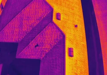
Standard visual inspections are limited by what the human eye can detect. A roof membrane might look perfectly intact while the substrate beneath it is rotting. Thermal imaging changes the equation by detecting the thermal capacitance of water.
Why This Matters:
- Heat Retention: Water holds heat longer than dry roofing materials. As the sun sets and the roof cools, trapped moisture remains "hot" on the thermal spectrum.
- Early Intervention: Detecting these "hot spots" allows for surgical repairs.
- Structural Integrity: Preventing long-term saturation protects the decking and support structures from corrosion and mold.
Precision Technology: The Enterprise Advantage
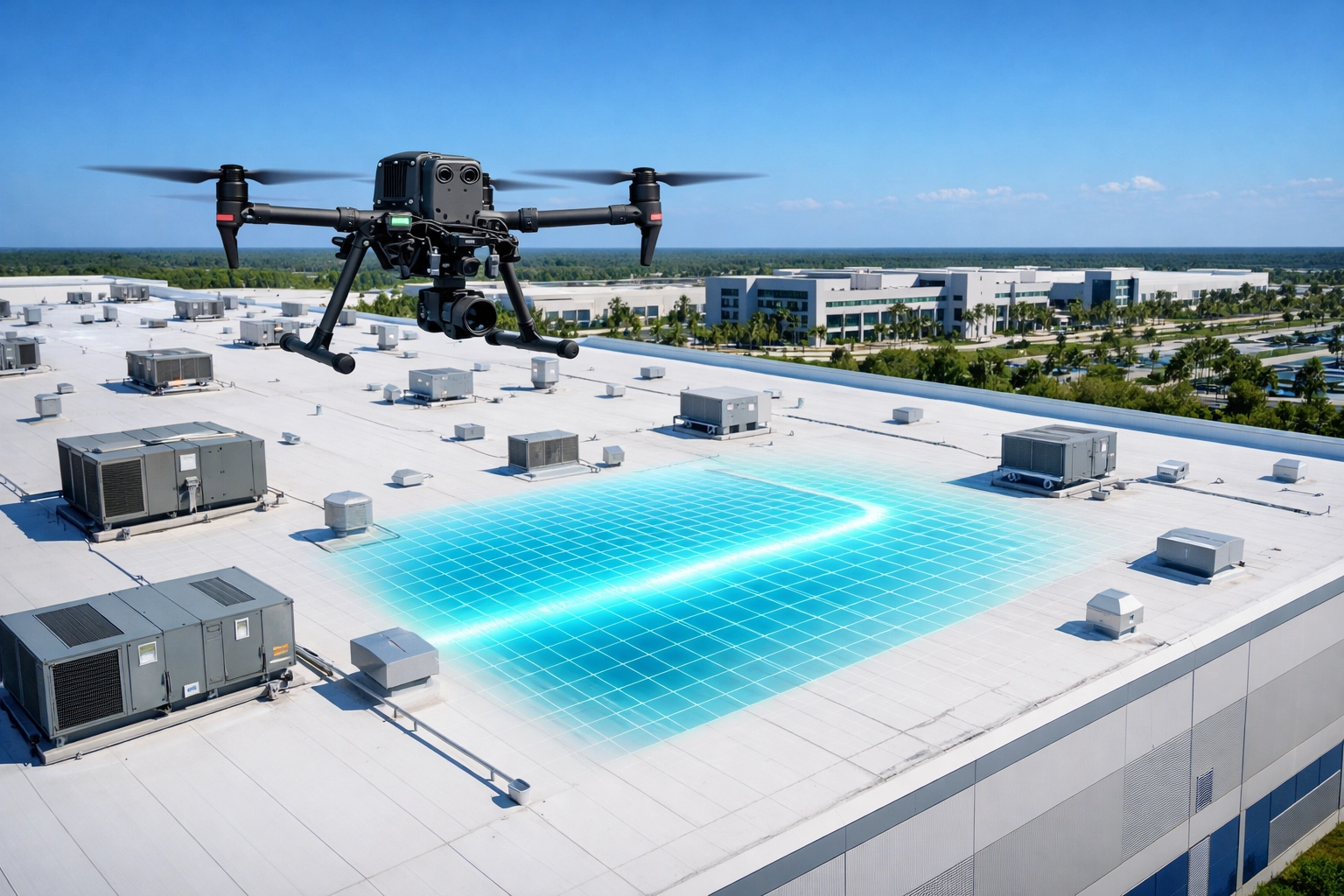
Not all drones are created equal. For a professional commercial roof inspection in Cape Coral, the equipment determines the quality of the data. At Cape UAV, our primary platform for these missions is the Autel Robotics EVO Lite 6T Enterprise (also known as the EVO Lite 640T).
This isn't a hobbyist camera. It features a specialized 640×512 thermal sensor alongside a 50MP visual camera. This dual-sensor setup allows us to overlay thermal data onto high-resolution visual imagery, providing a comprehensive view of the roof’s health.
Technical Capabilities:
- Radiometric Data: We don't just see colors; we capture temperature data for every pixel in the image.
- High Sensitivity: The 640×512 resolution ensures we can spot even small thermal anomalies from a safe flight altitude.
- Picture-in-Picture Mode: This allows our pilots to verify a thermal anomaly against a visual high-res photo in real-time to rule out debris or shadows.
Autel Robotics is a trademark of its respective owner; Cape UAV is not affiliated with or endorsed by Autel Robotics.
Speed, Safety, and Reduced Liability
Traditional roof inspections are inherently risky and time-consuming. Sending a crew onto a multi-story roof involves ladders, scaffolding, and significant man-hours. In SWFL, the heat and unpredictable weather add further complications to manual inspections.
Drone technology eliminates these variables. A thermal drone scan of a 50,000-square-foot facility that would take a manual crew several hours to inspect can be completed in approximately 20 minutes.
Why It Matters:
- Zero Fall Risk: No personnel need to leave the ground during the initial data capture phase.
- Minimal Disruption: There is no need to block off parking lots or move equipment for ladder access.
- Rapid Deployment: We can scan multiple buildings in a single day, providing a portfolio-wide health check in a fraction of the time.
ROI Advantage: Targeted Repairs vs. Full Replacement
The single greatest benefit of facility maintenance drone services is the impact on your bottom line. According to industry data, moisture intrusion is responsible for over half of all early roof failures. When a roof is replaced prematurely, it is often because the extent of the moisture damage was unknown.
Thermal scans allow for targeted repairs. If a scan reveals that only 5% of your roof insulation is saturated around a specific HVAC unit, you can fix that specific section for a few thousand dollars rather than spending $150,000 on a full roof replacement.
Financial Breakdown:
- Life Extension: Identifying and fixing leaks early can extend the life of a commercial roof by 5 to 10 years.
- Energy Efficiency: Saturated insulation loses its R-value, forcing your HVAC systems to work harder. Identifying these "energy leaks" supports lower utility costs.
- Insurance Documentation: Having a dated thermal scan provides clear evidence for insurance claims, proving that damage occurred during a specific storm event rather than through "gradual neglect."
| Feature | Traditional Inspection | Cape UAV Thermal Drone Scan |
|---|---|---|
| Time (50k sq. ft.) | 3–6 Hours | ~20 Minutes |
| Safety Risk | High (Falls/Ladders) | Negligible (Ground-based) |
| Detection Method | Visual/Manual Probing | Thermal Radiometry (FLIR) |
| Accuracy | Subjective | Data-Driven/Precise |
| Documentation | Handwritten Notes/Photos | High-Res Orthomosaics/Reports |
Comprehensive Reporting and Documentation
Data is only useful if it’s actionable. After a thermal imaging mission, Cape UAV provides a detailed report that visualizes the roof's condition. We use these scans to create high-resolution orthomosaics: large, detailed maps made from hundreds of individual photos stitched together.
These reports allow facility managers to:
- Prioritize Maintenance: Focus budgets on the most critical issues first.
- Verify Repairs: Scan the roof again after repairs are completed to ensure the moisture issue has been resolved.
- Capital Planning: Use year-over-year scans to track roof degradation and accurately predict when a full replacement will actually be necessary.
Why Cape UAV for SWFL Commercial Inspections?
Southwest Florida presents unique challenges for commercial roofing. Between the intense UV radiation, high humidity, and seasonal tropical storms, roofs here take a beating. A thermal drone scan in SWFL isn't just a good idea; it’s a necessary part of a hurricane-readiness and maintenance strategy.
We specialize in providing technical, data-focused aerial imaging for the construction and property management sectors. Whether you are managing an industrial complex in Cape Coral or a retail center in Fort Myers, our thermal workflows are designed to give you clarity and confidence in your asset management.
ROI Summary:
- Avoid unnecessary full replacements by identifying localized issues.
- Reduce inspection costs by 70% or more compared to manual labor.
- Enhance safety by keeping boots on the ground.
- Support energy efficiency by identifying compromised insulation.
Important Disclaimer
Thermal results indicate anomalies and are not a substitute for evaluation by a licensed professional. Cape UAV provides aerial data and imaging services. We are not licensed land surveyors or professional engineers. All mapping data is for informational purposes and should not be used as a legal survey or for engineering design without verification by a licensed professional in those respective fields. Our data is for planning purposes and is not a substitute for a licensed land survey.
Ready to stop guessing about your roof's condition?
Explore our thermal imaging services or contact us today to schedule a high-resolution scan of your facility.
Important Disclaimer:
Thermal results indicate anomalies and are not a substitute for evaluation by a licensed professional. Our data is for planning purposes and is not a substitute for a licensed land survey. Cape UAV provides aerial data and imaging services. We are not licensed land surveyors or professional engineers. All mapping data is for informational purposes and should not be used as a legal survey or for engineering design without verification by a licensed professional in those respective fields.