
Enterprise drone operations are no longer a luxury for construction and property management firms in Southwest Florida: they are a technical requirement. However, the gap between a consumer-grade hobbyist and a professional enterprise service provider is wide. Hiring the wrong provider results in more than just poor photos; it leads to regulatory exposure, unusable data sets, and missed ROI.
As high-resolution aerial imaging becomes the standard for facility maintenance and land development, avoiding these seven critical mistakes will protect your project and your budget.
1. Prioritizing the Lowest Bid Over Data Fidelity
The most common error is selecting a drone provider based solely on a quotation. In the world of aerial data, price is often a direct reflection of equipment capability and pilot expertise. Low-cost operators frequently utilize consumer-grade hardware that lacks the sensor precision required for technical applications.
For professional facility inspections, equipment specifications like the Autel Robotics EVO Lite 6T Enterprise are the baseline. This platform features a 640×512 thermal sensor and a 50MP visual camera, providing the detail necessary to identify structural anomalies that cheaper drones simply cannot see.
Why This Matters
- Data Integrity: Low-resolution sensors produce "noisy" images that hide critical defects.
- Re-work Costs: Inaccurate data often requires a second flight, doubling your initial "savings."
- Deliverable Quality: Professional platforms offer the dynamic range needed to capture detail in the harsh Southwest Florida sun.
ROI Advantage
Investing in high-resolution data ensures that issues are identified correctly the first time. Detecting a minor moisture intrusion via thermal imaging before it becomes a structural failure saves tens of thousands in repair costs.
2. Ignoring FAA Part 107 Compliance and Insurance
Operating a drone for any commercial purpose: including real estate, construction progress, or site inspections: requires an FAA Part 107 certification. Hiring an uncertified pilot is a significant legal risk for your business. If an accident occurs or the FAA investigates, the hiring party can be held liable for utilizing an unauthorized operator.
Furthermore, professional insurance is non-negotiable. Standard general liability policies often exclude "aviation" or "unmanned aircraft." Ensure your provider carries a dedicated drone insurance policy with adequate hull and liability coverage.
Why This Matters
- Legal Compliance: FAA fines for unauthorized commercial operations can be substantial.
- Risk Mitigation: Professional insurance protects your property and the public during flight operations.
- Professionalism: Part 107 certification ensures the pilot understands airspace restrictions around airports like RSW or Page Field.
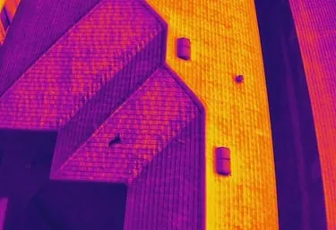
3. Overlooking Thermal Sensor Resolution (The 640×512 Standard)
For thermal imaging, not all sensors are equal. Many entry-level "thermal" drones use 160×120 or 320×240 sensors. These are insufficient for roof inspections or electrical grid analysis.
Cape UAV utilizes enterprise-grade thermal sensors with a 12um pixel pitch. This technical specification refers to the distance between pixels on the sensor; a smaller pitch allows for higher thermal sensitivity and clearer imagery from greater distances.
Why This Matters
- Precision: A 640×512 sensor has four times the pixels of a 320×240 sensor.
- Thermal Sensitivity: Higher sensitivity allows for the detection of minute temperature variations that indicate energy loss or electrical overheating.
- Operational Safety: Higher resolution allows the drone to fly at a safer altitude while still capturing granular data.
4. Confusing "Photography" with Technical "Mapping"
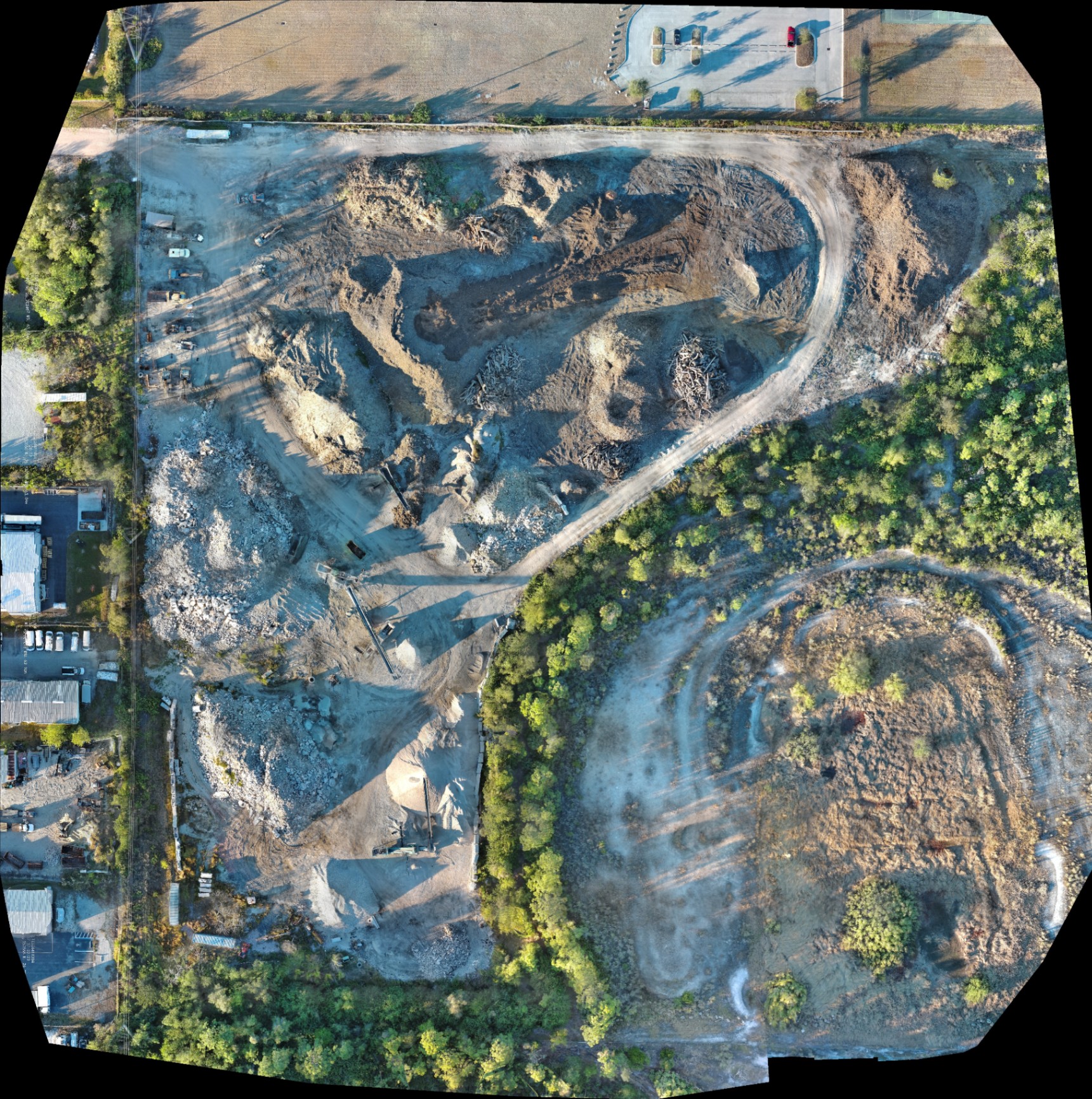
A common mistake is hiring a photographer for a mapping or 3D modeling project. High-resolution photography is about aesthetics; precision mapping is about data.
Mapping requires specific flight paths with high overlap (usually 70-80%) and post-processing software to create orthomosaic maps, Digital Surface Models (DSM), and 3D point clouds. This data is essential for land development and site planning, but it is a distinct technical discipline from standard aerial photography.
Comparison Table: Marketing vs. Technical Aerial Services
| Feature | Marketing/Real Estate | Technical Mapping/Modeling |
|---|---|---|
| Primary Goal | Visual Appeal | Data Accuracy & Planning |
| Output Type | Edited Photos/Video | Orthomosaics/3D Models |
| Camera Angle | Variable/Oblique | Nadir (Straight Down) |
| Hardware Focus | Color Reproduction | GPS Precision & Sensor Resolution |
| Post-Processing | Color Grading | Photogrammetry Reconstruction |

5. Failing to Define Clear Deliverables and Workflows
Ambiguity in the project scope leads to misaligned expectations. Before hiring, you must determine exactly what data you need. Do you need raw footage, a processed 3D model, or a PDF inspection report?
Standardized workflows are the hallmark of a professional enterprise drone service. This includes:
- Pre-flight Planning: Checking NOTAMs, weather, and airspace.
- On-site Safety: Use of visual observers and flight manifests.
- Data Security: Ensuring data is handled according to your company’s privacy standards.
Why This Matters
Without a defined workflow, data consistency vanishes. If you are tracking construction progress over six months, every flight must be executed with identical parameters to ensure the maps align perfectly for comparison.
6. Neglecting Local Southwest Florida Expertise
Southwest Florida presents unique challenges for drone operations. High heat can cause battery degradation and sensor noise, while rapid weather shifts require a pilot who understands local micro-climates. Furthermore, proximity to local airports and restricted airspaces requires specific knowledge of LAANC (Low Altitude Authorization and Notification Capability) protocols.
Why This Matters
- Environmental Reliability: Professional equipment like the Autel EVO Lite 6T Enterprise is designed for higher operating temperatures.
- Local Logistics: An experienced local provider knows how to navigate the specific permitting and airspace requirements of Cape Coral and Lee County.
7. Assuming "More Is Better" Regarding Flight Time
Clients often focus on how long the drone can stay in the air. However, in professional mapping and thermal inspection, efficiency is measured by Data Capture Rate, not flight time.
An enterprise drone with a high-resolution sensor can capture the same amount of data in one 20-minute flight that a cheaper drone might take an hour to capture. This is because the higher-resolution sensor allows for a wider "footprint" on the ground with each click of the shutter, requiring fewer flight lines.
ROI Advantage
Faster data capture means less time on-site, fewer disruptions to your facility operations, and faster turnaround for processed deliverables.
The Professional Advantage: Autel Robotics EVO Lite 6T Enterprise
At Cape UAV, we prioritize the technical specs that drive business value. Our primary platform, the Autel Robotics EVO Lite 6T Enterprise, is specifically chosen for Southwest Florida's B2B environment.
- Dual Camera System: Simultaneously captures thermal and visual data.
- 640×512 Thermal Resolution: Meets the professional standard for industrial inspections.
- 50MP Visual Sensor: Delivers the clarity needed for high-end real estate and construction documentation.
- Rapid Deployment: Gets on-site and in the air quickly, minimizing downtime.
(Autel Robotics is a trademark of its respective owner; Cape UAV is not affiliated with or endorsed by Autel Robotics. Results depend on environmental and flight conditions.)
Summary: How to Hire Correctly
To get the most out of your drone service investment, follow this checklist:
- Verify Certification: Ask for a copy of the pilot's FAA Part 107 card.
- Check Hardware Specs: Ensure the thermal sensor is at least 640×512.
- Review the Portfolio: Look for technical mapping or thermal examples, not just sunset photos.
- Confirm Insurance: Ensure the policy explicitly covers aviation/UAS operations.
- Define the Data: Specify if you need raw files or processed orthomosaics.
By focusing on technical capability and regulatory compliance, you transform drone services from a simple "photo op" into a powerful data tool that supports your land development and facility maintenance goals.
Important Disclaimer
Mapping Disclaimer: Our data is for planning purposes and is not a substitute for a licensed land survey.
Thermal Disclaimer: Thermal results indicate anomalies and are not a substitute for evaluation by a licensed professional.
Important Disclaimer
Our data is for planning purposes and is not a substitute for a licensed land survey. Thermal results indicate anomalies and are not a substitute for evaluation by a licensed professional.