
In the high-stakes world of Southwest Florida construction, information is the most valuable currency. For project managers in Cape Coral and the surrounding regions, traditional site monitoring often lags behind the actual pace of work: leading to expensive rework, scheduling bottlenecks, and missed milestones.
Integrating precision drone mapping into your construction timeline transforms the site from a series of manual checkpoints into a data-driven environment. At Cape UAV, we utilize enterprise-grade technology like the Autel Robotics EVO Lite 6T Enterprise, featuring a 50MP visual camera and a 640×512 thermal sensor, to deliver high-resolution mapping for planning purposes. This approach ensures that every stakeholder, from the site superintendent to the developer, has a clear view of progress in near real-time.
Phase 1: Pre-Construction and Baseline Documentation
The success of a project is often determined before the first shovel hits the ground. Integrating drone services during the pre-construction phase establishes a definitive baseline. By capturing a high-resolution orthomosaic map, teams can visualize existing site conditions, terrain elevations, and potential obstacles that might not be visible from ground level.
Why It Matters
- Identifies Early Constraints: Reveals drainage patterns or hidden debris that could impact site clearing.
- Facilitates Design Accuracy: Provides a visual overlay for CAD and BIM files to ensure design plans align with reality.
- Legal Protection: Creates a visual record of the site and surrounding infrastructure before work begins, protecting against future liability claims.
ROI Advantage
Starting with an accurate digital twin of the site eliminates the "surprises" that typically cause 10-15% cost overruns in the early stages of land development.
Phase 2: Earthworks and Site Preparation
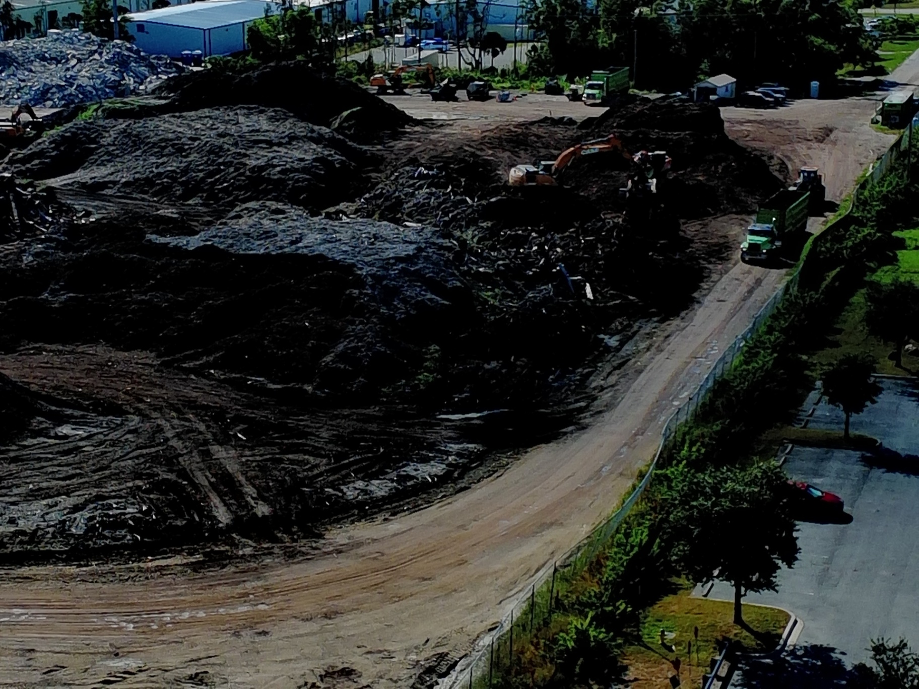
During the earthworks phase, volume is everything. Traditionally, calculating how much dirt has been moved or how much fill is needed requires manual topographic checks that can take days to process. Precision drone mapping streamlines this by generating 3D models and digital surface models (DSMs) in hours.
Workflow Automation
Instead of manual site walks, we deploy automated flight plans. The drone captures thousands of data points across the site, which are then processed into volumetric data. This allows project managers to track stockpiles and excavation pits with high frequency: often weekly or even daily: without stopping work on the ground.
Why This Matters
- Verification: Quickly verify if the grade matches the design specifications.
- Logistics Management: Track exactly how much material is on-site to optimize truck scheduling and material deliveries.
- Subcontractor Accountability: Pay based on actual material moved rather than estimates.
ROI Advantage
Drone-based progress tracking delivers 50–75% faster turnaround for progress verification compared to traditional methods. This eliminates "idle days" where machines sit still waiting for a site check.
Phase 3: Structural Phase and Thermal Integration
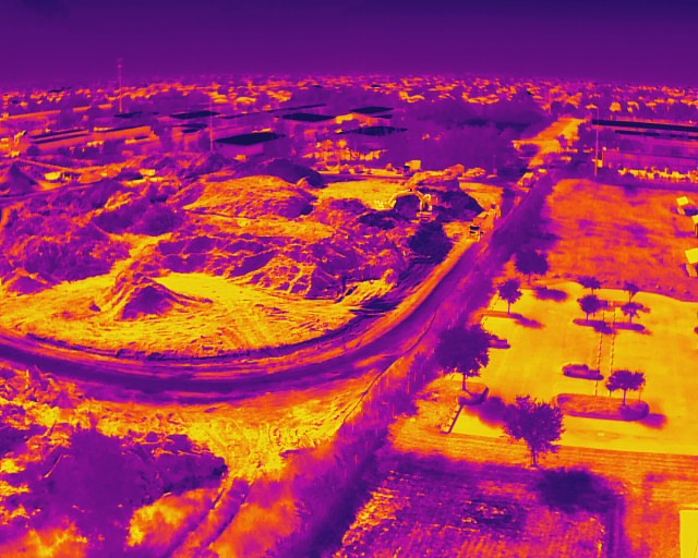
As the project moves into vertical construction, the focus shifts to quality control and structural integrity. This is where thermal imaging becomes a critical component of the timeline. Using the 640×512 thermal sensor on our Autel platform, we can detect anomalies that the human eye: and standard cameras: simply cannot see.
The Thermal-First Approach
Integrating thermal inspections during construction allows for the identification of moisture intrusion, insulation gaps, or electrical hotspots before the building is enclosed. This is particularly vital in the humid climate of Southwest Florida, where moisture management is paramount for long-term facility maintenance.
Why It Matters
- Moisture Detection: Identify leaks in plumbing or roofing systems during the testing phase.
- Insulation Integrity: Verify the thermal envelope of the building before the interior finishing begins.
- Electrical Safety: Inspect temporary and permanent electrical panels for hotspots to prevent site fires.
Phase 4: Integration with Project Management Software
Data is only useful if it is accessible. The modern construction timeline relies on seamless communication between the field and the office. We provide high-resolution visual and thermal data that integrates directly into project management and GIS platforms.
Streamlined Deliverables
- Orthomosaics: High-resolution, stitched-together maps for site-wide overviews.
- 3D Models: Interactive meshes used for walkthroughs and stakeholder presentations.
- Progress Reports: Side-by-side comparisons of the site over time.
By integrating these deliverables into your existing workflow, you eliminate manual data entry and human error. Stakeholders can access the latest site conditions from any device, ensuring everyone is working from the same "source of truth."

The Technical Edge: Autel Robotics EVO Lite 6T Enterprise
At Cape UAV, we believe that the quality of your data is limited by the quality of your hardware. Our primary platform for construction and industrial mapping is the Autel Robotics EVO Lite 6T Enterprise.
Technical Specifications for Construction Utility:
- Dual Camera System: A 50MP visual camera for crisp orthomosaics and a 640×512 thermal sensor for detailed inspection.
- 12um Pixel Pitch: Higher sensitivity for thermal detection, allowing us to find smaller anomalies from greater distances.
- Rapid Deployment: The ability to be airborne in minutes, minimizing site disruption.
- FAA Part 107 Certified: All missions are flown by certified professionals adhering to strict safety and legal protocols.
Note: Autel Robotics is a trademark of its respective owner; Cape UAV is not affiliated with or endorsed by Autel Robotics.
Summary of Timeline Integration Benefits
| Construction Phase | Drone Mapping Utility | Primary Benefit |
|---|---|---|
| Pre-Construction | High-Res Orthomosaics | Baseline documentation & design validation |
| Earthworks | Volumetric Analysis | Precise tracking of material movement |
| Structural | 3D Modeling & Visual Progress | Enhanced stakeholder communication |
| Enclosure | 640×512 Thermal Inspection | Early detection of moisture and heat anomalies |
| Post-Construction | Final Site Records | As-built documentation for facility management |
ROI Advantage: The Bottom Line
Integrating precision drone mapping isn't just an "add-on" service: it's a cost-saving strategy. By identifying grading errors early, verifying subcontractor progress with visual proof, and detecting moisture issues via thermal imaging before they escalate, the technology pays for itself many times over.
In Southwest Florida’s competitive development landscape, the ability to deliver projects on time and under budget is what sets the leaders apart. High-resolution mapping for planning purposes provides the clarity, confidence, and control required to manage complex construction timelines effectively.
Important Disclaimer
Mapping Disclaimer: Our data is for planning purposes and is not a substitute for a licensed land survey.
Thermal Disclaimer: Thermal results indicate anomalies and are not a substitute for evaluation by a licensed professional.
For more information on how we support industrial and construction projects in Cape Coral and beyond, visit our FAQ page or contact us to discuss your next project.
Important Disclaimer
Our data is for planning purposes and is not a substitute for a licensed land survey. Thermal results indicate anomalies and are not a substitute for evaluation by a licensed professional. Results depend on environmental conditions and site-specific variables. High-resolution imagery and 3D models are intended for progress documentation, inventory management, and planning support.