
Industrial site management in the modern era requires a shift from manual oversight to data-driven intelligence. Aerial visuals: the integration of high-resolution photogrammetry, thermal imaging, and 3D modeling: provide the clarity, confidence, and control necessary to manage complex assets. In Southwest Florida, where environmental factors and rapid development create unique challenges, leveraging enterprise-grade drone technology is no longer optional for maintaining a competitive edge.
The following guide outlines the technical capabilities, applications, and financial advantages of incorporating professional aerial visuals into your industrial workflow.
High-Resolution Orthomosaic Mapping: The Digital Twin
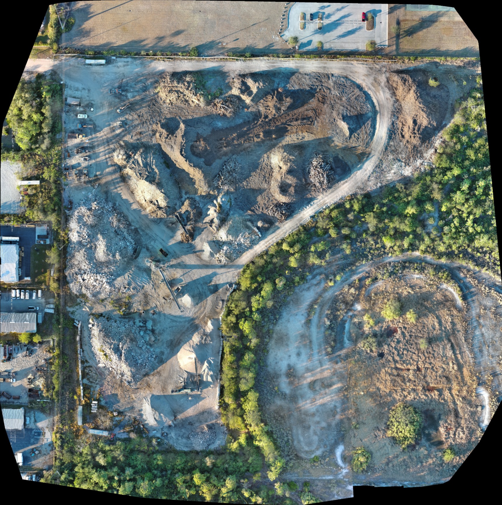
An orthomosaic is a geometrically corrected aerial photograph composed of hundreds, or even thousands, of individual high-resolution images stitched together. Unlike a standard aerial photo, an orthomosaic provides a uniform scale across the entire map, allowing for accurate planning and documentation.
Why It Matters
Traditional site walkthroughs provide a fragmented view of operations. A high-resolution orthomosaic delivers a comprehensive, top-down perspective of the entire site in a single, high-detail file. This eliminates the "information silos" that occur when different teams have different understandings of site conditions.
- Site Planning: Coordinate the placement of heavy machinery, material stockpiles, and temporary structures with centimeter-level detail.
- Progress Tracking: Weekly or bi-weekly flights provide a historical record of site evolution, ensuring projects remain on schedule.
- Resource Allocation: Identify underutilized equipment or bottlenecked areas immediately.
ROI Advantage: By utilizing drone mapping to generate digital twins, site managers reduce the time spent on manual inspections by up to 80%. This allows for faster decision-making and reduces the likelihood of costly project delays.
Thermal Imaging for Preventative Maintenance
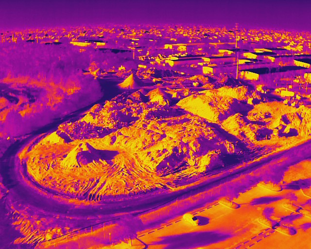
For industrial facilities, the most significant risks are often invisible to the naked eye. Thermal imaging detects infrared radiation, revealing temperature anomalies that indicate failing electrical components, structural weaknesses, or insulation breaches.
Cape UAV utilizes the Autel Robotics EVO Lite 6T Enterprise, featuring a 640×512 thermal sensor with a 12um pixel pitch. This technical specification is critical; a smaller pixel pitch results in higher resolution and better thermal sensitivity, allowing for the detection of minute temperature variations from a safe distance.
Why This Matters
Detecting a hot spot in an electrical panel or a leak in a flat roof before it leads to a catastrophic failure is the definition of proactive management.
- Substation Inspections: Identify overheating transformers or failing insulators without de-energizing the system.
- Roof Moisture Surveys: Locate trapped moisture beneath roof membranes to target repairs rather than replacing the entire surface.
- Solar Array Analysis: Quickly scan thousands of panels to find defective cells or string failures that are dragging down system efficiency.
ROI Advantage: One thermal inspection can identify a localized fault that, if left unchecked, could result in hundreds of thousands of dollars in emergency repairs and lost production time.
Precision 3D Modeling and Volumetric Analysis
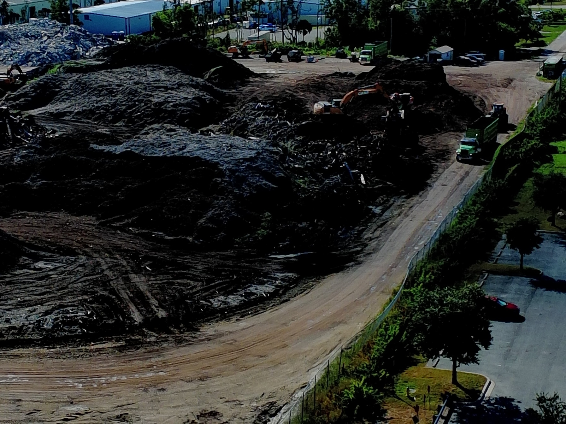
Beyond 2D maps, 3D modeling transforms aerial data into a functional digital environment. In land development and construction, understanding the topography and volume of materials on-site is essential for budget accuracy.
Why It Matters
Manual volumetric calculations are time-consuming and often involve putting personnel in hazardous areas, such as climbing large stockpiles. Drones capture this data from the air, providing high-density point clouds that can be converted into 3D meshes or Digital Elevation Models (DEM).
- Cut-and-Fill Analysis: Calculate exactly how much earth needs to be moved to reach the desired grade.
- Stockpile Management: Monitor inventory levels of gravel, sand, or debris with high frequency.
- Drainage Planning: Use elevation data to predict water runoff patterns: a critical factor for industrial sites in Cape Coral.
ROI Advantage: Eliminating the need for manual stockpile measurements increases safety and provides inventory data in hours rather than days. This level of precision prevents over-ordering of materials and ensures accurate billing for subcontractors.
The Technical Edge: Enterprise Hardware
The quality of industrial data is directly tied to the hardware used to capture it. Cape UAV operates the Autel Robotics EVO Lite 6T Enterprise (EVO Lite 640T), a platform designed specifically for the rigors of industrial inspection.
| Feature | Specification | Industrial Benefit |
|---|---|---|
| Visual Sensor | 50MP Camera | Ultra-sharp detail for structural inspections |
| Thermal Sensor | 640×512 Resolution | High-fidelity heat mapping and anomaly detection |
| Pixel Pitch | 12um | Superior sensitivity for detecting small thermal deltas |
| Operating Specs | FAA Part 107 Certified | Legal, insured, and professional operations |
Note: Autel Robotics is a trademark of its respective owner; Cape UAV is not affiliated with or endorsed by Autel Robotics. Results depend on environmental conditions.
Operational Efficiency and Hazard Detection
The primary goal of industrial site management is the mitigation of risk. Aerial visuals serve as an early warning system.
Hazard Identification
Drones can access areas that are dangerous for human inspectors, such as high-voltage areas, unstable slopes, or toxic environments. High-resolution visuals allow for the inspection of flare stacks, cooling towers, and bridge undercarriages without the need for scaffolding or heavy lifts.
Site Cleanup and Coordination
For large-scale industrial projects or post-disaster recovery, aerial imagery provides a comprehensive view of debris. This data allows managers to coordinate cleanup efforts efficiently, identifying the optimal routes for heavy machinery and tracking the progress of debris removal in real-time.
Maximizing ROI Through Frequency
The value of aerial data increases exponentially with the frequency of capture. A single flight provides a snapshot; regular flights provide a trend.
- Baseline Documentation: Capture the site condition before any work begins to protect against liability.
- Milestone Audits: Use drone services at critical project stages to verify work quality and compliance with design specifications.
- Annual Maintenance: Schedule yearly thermal inspections of facility envelopes and electrical systems to identify degradation before it causes a failure.
By integrating these visuals into your project management software, you create a transparent workflow where every stakeholder has access to the same high-resolution data.
Important Disclaimer
Important Disclaimer: Our data is for planning purposes and is not a substitute for a licensed land survey. Thermal results indicate anomalies and are not a substitute for evaluation by a licensed professional.
Conclusion: The Future of Site Oversight
As industrial operations become more complex, the margin for error shrinks. High-resolution aerial visuals provide the technical foundation for modern site management, offering a level of oversight that was previously unattainable. From the thermal detection of hidden faults to the precision of 3D volumetric analysis, these tools deliver a measurable return on investment through improved safety, reduced downtime, and enhanced project clarity.
By partnering with an FAA Part 107-certified provider like Cape UAV, industrial managers in Southwest Florida can leverage enterprise-grade technology to protect their assets and optimize their operations year-round.
Important Disclaimer: Our data is for planning purposes and is not a substitute for a licensed land survey. Thermal results indicate anomalies and are not a substitute for evaluation by a licensed professional.